You are here: Home > Network List > N4 - Central and EAstern US Network Stations List
> Station I62A Tamworth, NH, USA > Earthquake Result Viewer
I62A Tamworth, NH, USA - Earthquake Result Viewer
| Earthquake location: |
Near Coast Of Ecuador |
| Earthquake latitude/longitude: |
-2.9/-79.8 |
| Earthquake time(UTC): |
2023/03/18 (077) 17:12:53 GMT |
| Earthquake Depth: |
66 km |
| Earthquake Magnitude: |
6.7 Mww |
| Earthquake Catalog/Contributor: |
NEIC PDE/us |
|
| Network: |
N4 Central and EAstern US Network |
| Station: |
I62A Tamworth, NH, USA |
| Lat/Lon: |
43.87 N/71.34 W |
| Elevation: |
264 m |
|
| Distance: |
47.1 deg |
| Az: |
8.351 deg |
| Baz: |
191.571 deg |
| Ray Param: |
0.06999522 |
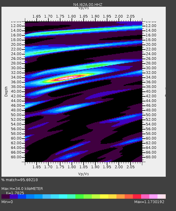
| Estimated Moho Depth: |
34.0 km |
| Estimated Crust Vp/Vs: |
1.78 |
| Assumed Crust Vp: |
6.419 km/s |
| Estimated Crust Vs: |
3.601 km/s |
| Estimated Crust Poisson's Ratio: |
0.27 |
|
| Radial Match: |
95.69218 % |
| Radial Bump: |
254 |
| Transverse Match: |
87.34003 % |
| Transverse Bump: |
400 |
| SOD ConfigId: |
30536071 |
| Insert Time: |
2023-04-01 17:34:15.973 +0000 |
| GWidth: |
2.5 |
| Max Bumps: |
400 |
| Tol: |
0.001 |
|

Signal To Noise
| Channel | StoN | STA | LTA |
| N4:I62A:00:HHZ:20230318T17:20:48.15901Z | 3.9002976 | 2.158105E-6 | 5.5331805E-7 |
| N4:I62A:00:HH1:20230318T17:20:48.15901Z | 3.534205 | 8.185249E-7 | 2.3160085E-7 |
| N4:I62A:00:HH2:20230318T17:20:48.15901Z | 0.61756676 | 2.2866851E-7 | 3.7027334E-7 |
| Arrivals |
| Ps | 4.4 SECOND |
| PpPs | 14 SECOND |
| PsPs/PpSs | 18 SECOND |


