You are here: Home > Network List > TA - USArray Transportable Network (new EarthScope stations) Stations List
> Station 434A Burnet, TX, USA > Earthquake Result Viewer
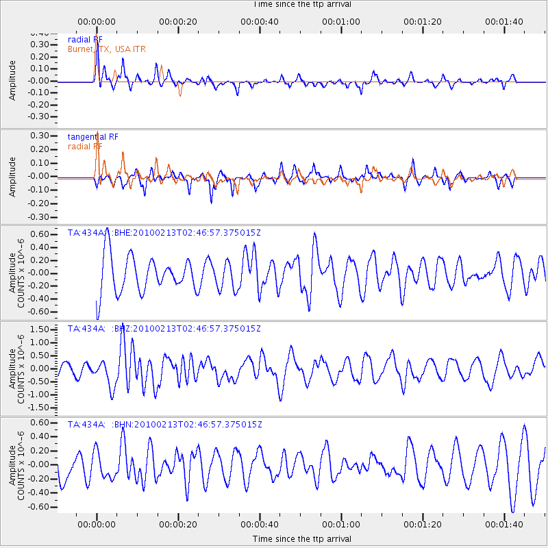
434A Burnet, TX, USA - Earthquake Result Viewer
*The percent match for this event was below the threshold and hence no stack was calculated.
| Earthquake location: |
Tonga Islands |
| Earthquake latitude/longitude: |
-21.9/-174.8 |
| Earthquake time(UTC): |
2010/02/13 (044) 02:34:28 GMT |
| Earthquake Depth: |
11 km |
| Earthquake Magnitude: |
6.0 MB, 6.2 MS, 6.1 MW, 6.0 MW |
| Earthquake Catalog/Contributor: |
WHDF/NEIC |
|
| Network: |
TA USArray Transportable Network (new EarthScope stations) |
| Station: |
434A Burnet, TX, USA |
| Lat/Lon: |
30.81 N/98.27 W |
| Elevation: |
462 m |
|
| Distance: |
90.1 deg |
| Az: |
56.779 deg |
| Baz: |
244.558 deg |
| Ray Param: |
$rayparam |
*The percent match for this event was below the threshold and hence was not used in the summary stack. |
|
| Radial Match: |
54.16955 % |
| Radial Bump: |
312 |
| Transverse Match: |
54.342026 % |
| Transverse Bump: |
286 |
| SOD ConfigId: |
306082 |
| Insert Time: |
2010-05-06 07:28:28.043 +0000 |
| GWidth: |
2.5 |
| Max Bumps: |
400 |
| Tol: |
0.001 |
|
Signal To Noise
| Channel | StoN | STA | LTA |
| TA:434A: :BHZ:20100213T02:46:57.375015Z | 2.203558 | 5.2235544E-7 | 2.3705091E-7 |
| TA:434A: :BHN:20100213T02:46:57.375015Z | 0.82998836 | 1.8728858E-7 | 2.2565206E-7 |
| TA:434A: :BHE:20100213T02:46:57.375015Z | 0.74856794 | 2.1224847E-7 | 2.8353935E-7 |
| Arrivals |
| Ps | |
| PpPs | |
| PsPs/PpSs | |


