You are here: Home > Network List > N4 - Central and EAstern US Network Stations List
> Station T57A Hurt, VA, USA > Earthquake Result Viewer
T57A Hurt, VA, USA - Earthquake Result Viewer
| Earthquake location: |
Near Coast Of Ecuador |
| Earthquake latitude/longitude: |
-2.9/-79.8 |
| Earthquake time(UTC): |
2023/03/18 (077) 17:12:53 GMT |
| Earthquake Depth: |
66 km |
| Earthquake Magnitude: |
6.7 Mww |
| Earthquake Catalog/Contributor: |
NEIC PDE/us |
|
| Network: |
N4 Central and EAstern US Network |
| Station: |
T57A Hurt, VA, USA |
| Lat/Lon: |
37.00 N/79.25 W |
| Elevation: |
230 m |
|
| Distance: |
39.6 deg |
| Az: |
0.685 deg |
| Baz: |
180.855 deg |
| Ray Param: |
0.07466355 |
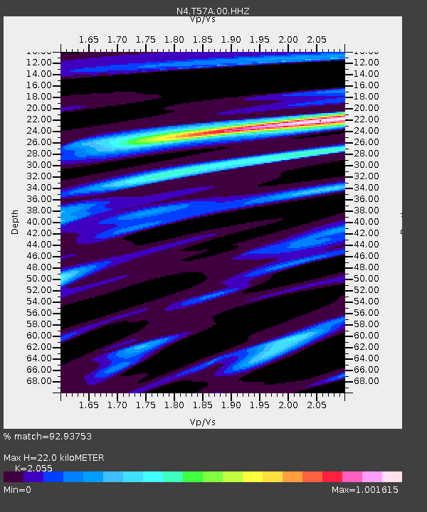
| Estimated Moho Depth: |
22.0 km |
| Estimated Crust Vp/Vs: |
2.06 |
| Assumed Crust Vp: |
6.419 km/s |
| Estimated Crust Vs: |
3.124 km/s |
| Estimated Crust Poisson's Ratio: |
0.34 |
|
| Radial Match: |
92.93753 % |
| Radial Bump: |
291 |
| Transverse Match: |
73.91911 % |
| Transverse Bump: |
400 |
| SOD ConfigId: |
30536071 |
| Insert Time: |
2023-04-01 17:36:01.582 +0000 |
| GWidth: |
2.5 |
| Max Bumps: |
400 |
| Tol: |
0.001 |
|

Signal To Noise
| Channel | StoN | STA | LTA |
| N4:T57A:00:HHZ:20230318T17:19:48.047987Z | 4.178265 | 1.5837203E-6 | 3.7903777E-7 |
| N4:T57A:00:HH1:20230318T17:19:48.047987Z | 4.046813 | 1.171914E-6 | 2.8958937E-7 |
| N4:T57A:00:HH2:20230318T17:19:48.047987Z | 1.5749915 | 3.8703217E-7 | 2.4573603E-7 |
| Arrivals |
| Ps | 3.8 SECOND |
| PpPs | 9.9 SECOND |
| PsPs/PpSs | 14 SECOND |


