You are here: Home > Network List > N4 - Central and EAstern US Network Stations List
> Station Z38B Mount Pleasant, TX, USA > Earthquake Result Viewer
Z38B Mount Pleasant, TX, USA - Earthquake Result Viewer
| Earthquake location: |
Near Coast Of Ecuador |
| Earthquake latitude/longitude: |
-2.9/-79.8 |
| Earthquake time(UTC): |
2023/03/18 (077) 17:12:53 GMT |
| Earthquake Depth: |
66 km |
| Earthquake Magnitude: |
6.7 Mww |
| Earthquake Catalog/Contributor: |
NEIC PDE/us |
|
| Network: |
N4 Central and EAstern US Network |
| Station: |
Z38B Mount Pleasant, TX, USA |
| Lat/Lon: |
33.26 N/94.99 W |
| Elevation: |
115 m |
|
| Distance: |
38.7 deg |
| Az: |
339.44 deg |
| Baz: |
155.252 deg |
| Ray Param: |
0.075254396 |
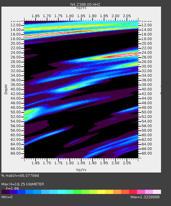
| Estimated Moho Depth: |
16.25 km |
| Estimated Crust Vp/Vs: |
1.66 |
| Assumed Crust Vp: |
6.245 km/s |
| Estimated Crust Vs: |
3.762 km/s |
| Estimated Crust Poisson's Ratio: |
0.22 |
|
| Radial Match: |
88.077866 % |
| Radial Bump: |
326 |
| Transverse Match: |
61.38865 % |
| Transverse Bump: |
400 |
| SOD ConfigId: |
30536071 |
| Insert Time: |
2023-04-01 17:36:38.797 +0000 |
| GWidth: |
2.5 |
| Max Bumps: |
400 |
| Tol: |
0.001 |
|

Signal To Noise
| Channel | StoN | STA | LTA |
| N4:Z38B:00:HHZ:20230318T17:19:39.970015Z | 12.1316 | 3.1340317E-6 | 2.583362E-7 |
| N4:Z38B:00:HH1:20230318T17:19:39.970015Z | 2.5206406 | 1.4689011E-6 | 5.827492E-7 |
| N4:Z38B:00:HH2:20230318T17:19:39.970015Z | 2.2947881 | 1.3997102E-6 | 6.099518E-7 |
| Arrivals |
| Ps | 1.8 SECOND |
| PpPs | 6.4 SECOND |
| PsPs/PpSs | 8.3 SECOND |


