You are here: Home > Network List > NE - New England Seismic Network Stations List
> Station EMMW Machias, ME, USA > Earthquake Result Viewer
EMMW Machias, ME, USA - Earthquake Result Viewer
| Earthquake location: |
Near Coast Of Ecuador |
| Earthquake latitude/longitude: |
-2.9/-79.8 |
| Earthquake time(UTC): |
2023/03/18 (077) 17:12:53 GMT |
| Earthquake Depth: |
66 km |
| Earthquake Magnitude: |
6.7 Mww |
| Earthquake Catalog/Contributor: |
NEIC PDE/us |
|
| Network: |
NE New England Seismic Network |
| Station: |
EMMW Machias, ME, USA |
| Lat/Lon: |
44.71 N/67.46 W |
| Elevation: |
35 m |
|
| Distance: |
48.6 deg |
| Az: |
11.721 deg |
| Baz: |
196.532 deg |
| Ray Param: |
0.06905123 |
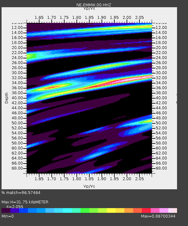
| Estimated Moho Depth: |
31.75 km |
| Estimated Crust Vp/Vs: |
2.06 |
| Assumed Crust Vp: |
6.419 km/s |
| Estimated Crust Vs: |
3.124 km/s |
| Estimated Crust Poisson's Ratio: |
0.34 |
|
| Radial Match: |
96.57464 % |
| Radial Bump: |
204 |
| Transverse Match: |
84.738976 % |
| Transverse Bump: |
386 |
| SOD ConfigId: |
30536071 |
| Insert Time: |
2023-04-01 17:36:51.773 +0000 |
| GWidth: |
2.5 |
| Max Bumps: |
400 |
| Tol: |
0.001 |
|

Signal To Noise
| Channel | StoN | STA | LTA |
| NE:EMMW:00:HHZ:20230318T17:20:59.608992Z | 4.705162 | 2.2546096E-6 | 4.7917786E-7 |
| NE:EMMW:00:HH1:20230318T17:20:59.608992Z | 3.960854 | 1.2332271E-6 | 3.1135383E-7 |
| NE:EMMW:00:HH2:20230318T17:20:59.608992Z | 1.7404648 | 4.597222E-7 | 2.6413758E-7 |
| Arrivals |
| Ps | 5.5 SECOND |
| PpPs | 14 SECOND |
| PsPs/PpSs | 20 SECOND |


