You are here: Home > Network List > O2 - Oklahoma Consolidated Temporary Seismic Networks Stations List
> Station SC02 Maysville, Garvin & McClain Counties, OK, USA > Earthquake Result Viewer
SC02 Maysville, Garvin & McClain Counties, OK, USA - Earthquake Result Viewer
| Earthquake location: |
Near Coast Of Ecuador |
| Earthquake latitude/longitude: |
-2.9/-79.8 |
| Earthquake time(UTC): |
2023/03/18 (077) 17:12:53 GMT |
| Earthquake Depth: |
66 km |
| Earthquake Magnitude: |
6.7 Mww |
| Earthquake Catalog/Contributor: |
NEIC PDE/us |
|
| Network: |
O2 Oklahoma Consolidated Temporary Seismic Networks |
| Station: |
SC02 Maysville, Garvin & McClain Counties, OK, USA |
| Lat/Lon: |
34.80 N/97.39 W |
| Elevation: |
310 m |
|
| Distance: |
40.9 deg |
| Az: |
337.693 deg |
| Baz: |
152.571 deg |
| Ray Param: |
0.07390617 |
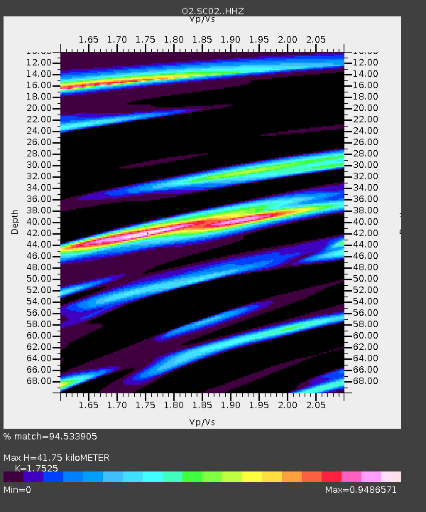
| Estimated Moho Depth: |
41.75 km |
| Estimated Crust Vp/Vs: |
1.75 |
| Assumed Crust Vp: |
6.426 km/s |
| Estimated Crust Vs: |
3.667 km/s |
| Estimated Crust Poisson's Ratio: |
0.26 |
|
| Radial Match: |
94.533905 % |
| Radial Bump: |
348 |
| Transverse Match: |
89.400116 % |
| Transverse Bump: |
394 |
| SOD ConfigId: |
30536071 |
| Insert Time: |
2023-04-01 17:39:59.514 +0000 |
| GWidth: |
2.5 |
| Max Bumps: |
400 |
| Tol: |
0.001 |
|

Signal To Noise
| Channel | StoN | STA | LTA |
| O2:SC02: :HHZ:20230318T17:19:58.645003Z | 16.257648 | 4.4454773E-6 | 2.7343913E-7 |
| O2:SC02: :HHN:20230318T17:19:58.645003Z | 3.9931116 | 1.8600381E-6 | 4.658117E-7 |
| O2:SC02: :HHE:20230318T17:19:58.645003Z | 2.9403486 | 1.3888522E-6 | 4.723427E-7 |
| Arrivals |
| Ps | 5.2 SECOND |
| PpPs | 17 SECOND |
| PsPs/PpSs | 22 SECOND |


