You are here: Home > Network List > O2 - Oklahoma Consolidated Temporary Seismic Networks Stations List
> Station SC14 Walters, Oklahoma, USA > Earthquake Result Viewer
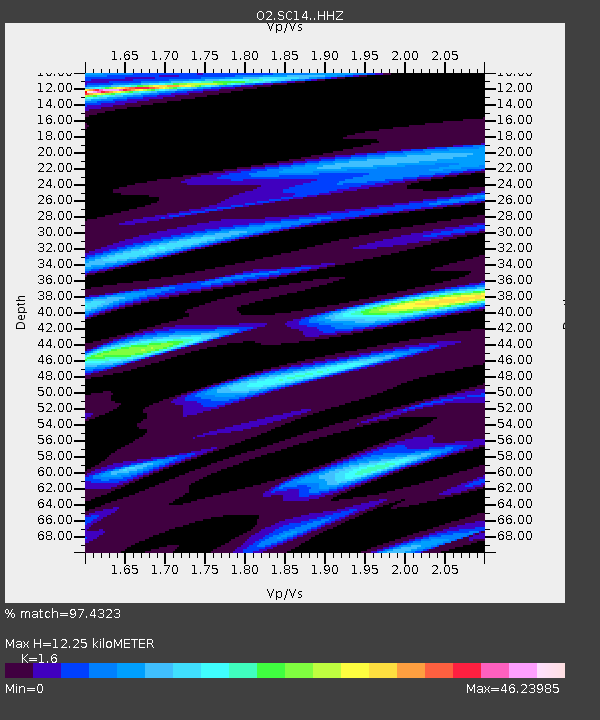
SC14 Walters, Oklahoma, USA - Earthquake Result Viewer
| Earthquake location: |
Near Coast Of Ecuador |
| Earthquake latitude/longitude: |
-2.9/-79.8 |
| Earthquake time(UTC): |
2023/03/18 (077) 17:12:53 GMT |
| Earthquake Depth: |
66 km |
| Earthquake Magnitude: |
6.7 Mww |
| Earthquake Catalog/Contributor: |
NEIC PDE/us |
|
| Network: |
O2 Oklahoma Consolidated Temporary Seismic Networks |
| Station: |
SC14 Walters, Oklahoma, USA |
| Lat/Lon: |
34.45 N/98.24 W |
| Elevation: |
339 m |
|
| Distance: |
41.0 deg |
| Az: |
336.497 deg |
| Baz: |
151.183 deg |
| Ray Param: |
0.073888704 |
| Estimated Moho Depth: |
12.25 km |
| Estimated Crust Vp/Vs: |
1.60 |
| Assumed Crust Vp: |
6.315 km/s |
| Estimated Crust Vs: |
3.947 km/s |
| Estimated Crust Poisson's Ratio: |
0.18 |
|
| Radial Match: |
97.4323 % |
| Radial Bump: |
309 |
| Transverse Match: |
92.37582 % |
| Transverse Bump: |
400 |
| SOD ConfigId: |
30536071 |
| Insert Time: |
2023-04-01 17:40:17.719 +0000 |
| GWidth: |
2.5 |
| Max Bumps: |
400 |
| Tol: |
0.001 |
|

Signal To Noise
| Channel | StoN | STA | LTA |
| O2:SC14: :HHZ:20230318T17:19:58.884993Z | 29.447285 | 1.4578761E-7 | 4.9507998E-9 |
| O2:SC14: :HHN:20230318T17:19:58.884993Z | 11.623656 | 3.2818543E-6 | 2.8234268E-7 |
| O2:SC14: :HHE:20230318T17:19:58.884993Z | 6.1743774 | 2.2048462E-6 | 3.5709613E-7 |
| Arrivals |
| Ps | 1.3 SECOND |
| PpPs | 4.7 SECOND |
| PsPs/PpSs | 5.9 SECOND |


