You are here: Home > Network List > O2 - Oklahoma Consolidated Temporary Seismic Networks Stations List
> Station SC15 Hammon, Oklahoma, USA > Earthquake Result Viewer
SC15 Hammon, Oklahoma, USA - Earthquake Result Viewer
| Earthquake location: |
Near Coast Of Ecuador |
| Earthquake latitude/longitude: |
-2.9/-79.8 |
| Earthquake time(UTC): |
2023/03/18 (077) 17:12:53 GMT |
| Earthquake Depth: |
66 km |
| Earthquake Magnitude: |
6.7 Mww |
| Earthquake Catalog/Contributor: |
NEIC PDE/us |
|
| Network: |
O2 Oklahoma Consolidated Temporary Seismic Networks |
| Station: |
SC15 Hammon, Oklahoma, USA |
| Lat/Lon: |
35.61 N/99.50 W |
| Elevation: |
550 m |
|
| Distance: |
42.5 deg |
| Az: |
335.995 deg |
| Baz: |
150.09 deg |
| Ray Param: |
0.07296597 |
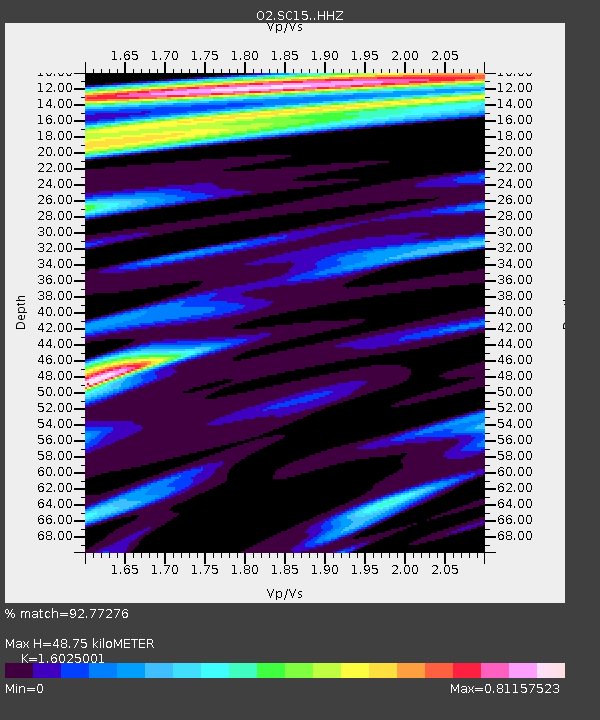
| Estimated Moho Depth: |
48.75 km |
| Estimated Crust Vp/Vs: |
1.60 |
| Assumed Crust Vp: |
6.315 km/s |
| Estimated Crust Vs: |
3.941 km/s |
| Estimated Crust Poisson's Ratio: |
0.18 |
|
| Radial Match: |
92.77276 % |
| Radial Bump: |
400 |
| Transverse Match: |
91.90347 % |
| Transverse Bump: |
400 |
| SOD ConfigId: |
30536071 |
| Insert Time: |
2023-04-01 17:40:20.028 +0000 |
| GWidth: |
2.5 |
| Max Bumps: |
400 |
| Tol: |
0.001 |
|

Signal To Noise
| Channel | StoN | STA | LTA |
| O2:SC15: :HHZ:20230318T17:20:11.185011Z | 11.802817 | 6.2321883E-6 | 5.2802545E-7 |
| O2:SC15: :HHN:20230318T17:20:11.185011Z | 2.8056676 | 1.4210359E-6 | 5.064876E-7 |
| O2:SC15: :HHE:20230318T17:20:11.185011Z | 2.2962294 | 7.872837E-8 | 3.4285932E-8 |
| Arrivals |
| Ps | 5.0 SECOND |
| PpPs | 19 SECOND |
| PsPs/PpSs | 24 SECOND |


