You are here: Home > Network List > O2 - Oklahoma Consolidated Temporary Seismic Networks Stations List
> Station STIG Stigler, Oklahoma, USA > Earthquake Result Viewer
STIG Stigler, Oklahoma, USA - Earthquake Result Viewer
| Earthquake location: |
Near Coast Of Ecuador |
| Earthquake latitude/longitude: |
-2.9/-79.8 |
| Earthquake time(UTC): |
2023/03/18 (077) 17:12:53 GMT |
| Earthquake Depth: |
66 km |
| Earthquake Magnitude: |
6.7 Mww |
| Earthquake Catalog/Contributor: |
NEIC PDE/us |
|
| Network: |
O2 Oklahoma Consolidated Temporary Seismic Networks |
| Station: |
STIG Stigler, Oklahoma, USA |
| Lat/Lon: |
35.34 N/95.11 W |
| Elevation: |
256 m |
|
| Distance: |
40.6 deg |
| Az: |
340.638 deg |
| Baz: |
156.107 deg |
| Ray Param: |
0.074103765 |
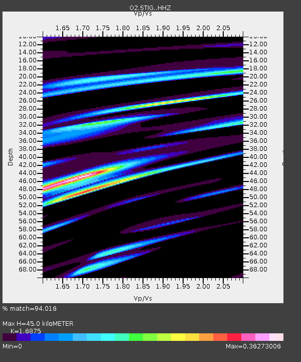
| Estimated Moho Depth: |
45.0 km |
| Estimated Crust Vp/Vs: |
1.69 |
| Assumed Crust Vp: |
6.498 km/s |
| Estimated Crust Vs: |
3.85 km/s |
| Estimated Crust Poisson's Ratio: |
0.23 |
|
| Radial Match: |
94.016 % |
| Radial Bump: |
400 |
| Transverse Match: |
84.60448 % |
| Transverse Bump: |
400 |
| SOD ConfigId: |
30536071 |
| Insert Time: |
2023-04-01 17:40:32.235 +0000 |
| GWidth: |
2.5 |
| Max Bumps: |
400 |
| Tol: |
0.001 |
|

Signal To Noise
| Channel | StoN | STA | LTA |
| O2:STIG: :HHZ:20230318T17:19:55.995009Z | 17.479948 | 3.4210138E-6 | 1.9571075E-7 |
| O2:STIG: :HHN:20230318T17:19:55.995009Z | 8.161296 | 1.7378565E-6 | 2.129388E-7 |
| O2:STIG: :HHE:20230318T17:19:55.995009Z | 2.7170982 | 1.0847986E-6 | 3.9924893E-7 |
| Arrivals |
| Ps | 5.1 SECOND |
| PpPs | 17 SECOND |
| PsPs/PpSs | 22 SECOND |


