You are here: Home > Network List > OH - Ohio Seismic Network Stations List
> Station MWLO Mercer Wildlife Area Ohio > Earthquake Result Viewer
MWLO Mercer Wildlife Area Ohio - Earthquake Result Viewer
| Earthquake location: |
Near Coast Of Ecuador |
| Earthquake latitude/longitude: |
-2.9/-79.8 |
| Earthquake time(UTC): |
2023/03/18 (077) 17:12:53 GMT |
| Earthquake Depth: |
66 km |
| Earthquake Magnitude: |
6.7 Mww |
| Earthquake Catalog/Contributor: |
NEIC PDE/us |
|
| Network: |
OH Ohio Seismic Network |
| Station: |
MWLO Mercer Wildlife Area Ohio |
| Lat/Lon: |
40.50 N/84.57 W |
| Elevation: |
266 m |
|
| Distance: |
43.4 deg |
| Az: |
354.703 deg |
| Baz: |
173.054 deg |
| Ray Param: |
0.072396934 |
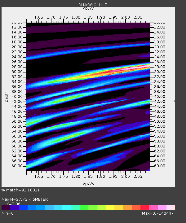
| Estimated Moho Depth: |
27.75 km |
| Estimated Crust Vp/Vs: |
2.06 |
| Assumed Crust Vp: |
6.498 km/s |
| Estimated Crust Vs: |
3.154 km/s |
| Estimated Crust Poisson's Ratio: |
0.35 |
|
| Radial Match: |
92.18821 % |
| Radial Bump: |
230 |
| Transverse Match: |
78.56527 % |
| Transverse Bump: |
400 |
| SOD ConfigId: |
30536071 |
| Insert Time: |
2023-04-01 17:40:55.161 +0000 |
| GWidth: |
2.5 |
| Max Bumps: |
400 |
| Tol: |
0.001 |
|

Signal To Noise
| Channel | StoN | STA | LTA |
| OH:MWLO: :HHZ:20230318T17:20:18.400008Z | 4.1435847 | 1.9281601E-6 | 4.653362E-7 |
| OH:MWLO: :HHN:20230318T17:20:18.400008Z | 2.867677 | 1.6413001E-6 | 5.7234485E-7 |
| OH:MWLO: :HHE:20230318T17:20:18.400008Z | 0.55648595 | 3.6612883E-7 | 6.5793006E-7 |
| Arrivals |
| Ps | 4.8 SECOND |
| PpPs | 12 SECOND |
| PsPs/PpSs | 17 SECOND |


