You are here: Home > Network List > OH - Ohio Seismic Network Stations List
> Station P51A Williamsport, OH, USA > Earthquake Result Viewer
P51A Williamsport, OH, USA - Earthquake Result Viewer
| Earthquake location: |
Near Coast Of Ecuador |
| Earthquake latitude/longitude: |
-2.9/-79.8 |
| Earthquake time(UTC): |
2023/03/18 (077) 17:12:53 GMT |
| Earthquake Depth: |
66 km |
| Earthquake Magnitude: |
6.7 Mww |
| Earthquake Catalog/Contributor: |
NEIC PDE/us |
|
| Network: |
OH Ohio Seismic Network |
| Station: |
P51A Williamsport, OH, USA |
| Lat/Lon: |
39.48 N/83.06 W |
| Elevation: |
211 m |
|
| Distance: |
42.2 deg |
| Az: |
356.246 deg |
| Baz: |
175.153 deg |
| Ray Param: |
0.07311267 |
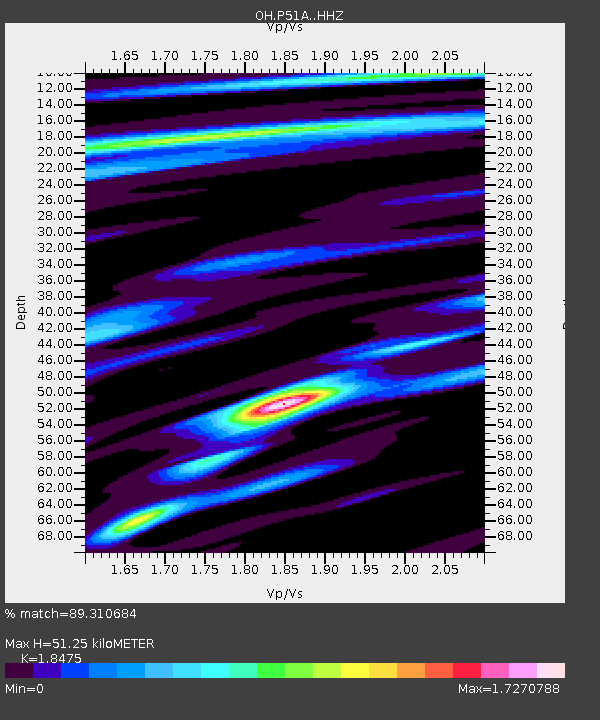
| Estimated Moho Depth: |
51.25 km |
| Estimated Crust Vp/Vs: |
1.85 |
| Assumed Crust Vp: |
6.232 km/s |
| Estimated Crust Vs: |
3.373 km/s |
| Estimated Crust Poisson's Ratio: |
0.29 |
|
| Radial Match: |
89.310684 % |
| Radial Bump: |
324 |
| Transverse Match: |
86.19409 % |
| Transverse Bump: |
359 |
| SOD ConfigId: |
30536071 |
| Insert Time: |
2023-04-01 17:40:58.621 +0000 |
| GWidth: |
2.5 |
| Max Bumps: |
400 |
| Tol: |
0.001 |
|

Signal To Noise
| Channel | StoN | STA | LTA |
| OH:P51A: :HHZ:20230318T17:20:09.240004Z | 3.465955 | 9.752523E-7 | 2.8138055E-7 |
| OH:P51A: :HHN:20230318T17:20:09.240004Z | 3.3362231 | 8.8208515E-7 | 2.6439633E-7 |
| OH:P51A: :HHE:20230318T17:20:09.240004Z | 0.91749567 | 4.8128296E-8 | 5.2456155E-8 |
| Arrivals |
| Ps | 7.4 SECOND |
| PpPs | 22 SECOND |
| PsPs/PpSs | 29 SECOND |


