You are here: Home > Network List > PQ - Public Safety Geoscience Program Canadian Research Network (PSGP) Stations List
> Station ULUN Ulukhaktok, Victoria Island, NWT, Canada > Earthquake Result Viewer
ULUN Ulukhaktok, Victoria Island, NWT, Canada - Earthquake Result Viewer
| Earthquake location: |
Near Coast Of Ecuador |
| Earthquake latitude/longitude: |
-2.9/-79.8 |
| Earthquake time(UTC): |
2023/03/18 (077) 17:12:53 GMT |
| Earthquake Depth: |
66 km |
| Earthquake Magnitude: |
6.7 Mww |
| Earthquake Catalog/Contributor: |
NEIC PDE/us |
|
| Network: |
PQ Public Safety Geoscience Program Canadian Research Network (PSGP) |
| Station: |
ULUN Ulukhaktok, Victoria Island, NWT, Canada |
| Lat/Lon: |
70.74 N/117.76 W |
| Elevation: |
5.0 m |
|
| Distance: |
77.6 deg |
| Az: |
347.934 deg |
| Baz: |
141.019 deg |
| Ray Param: |
0.05008986 |
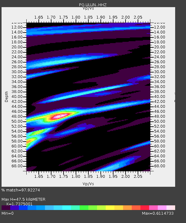
| Estimated Moho Depth: |
47.5 km |
| Estimated Crust Vp/Vs: |
1.74 |
| Assumed Crust Vp: |
6.367 km/s |
| Estimated Crust Vs: |
3.664 km/s |
| Estimated Crust Poisson's Ratio: |
0.25 |
|
| Radial Match: |
97.92274 % |
| Radial Bump: |
326 |
| Transverse Match: |
81.969894 % |
| Transverse Bump: |
400 |
| SOD ConfigId: |
30536071 |
| Insert Time: |
2023-04-01 17:42:50.949 +0000 |
| GWidth: |
2.5 |
| Max Bumps: |
400 |
| Tol: |
0.001 |
|

Signal To Noise
| Channel | StoN | STA | LTA |
| PQ:ULUN: :HHZ:20230318T17:24:11.099989Z | 9.9939785 | 1.6972591E-6 | 1.6982818E-7 |
| PQ:ULUN: :HHN:20230318T17:24:11.099989Z | 3.0509696 | 6.1277694E-7 | 2.0084663E-7 |
| PQ:ULUN: :HHE:20230318T17:24:11.099989Z | 3.9218683 | 5.1557214E-7 | 1.3146084E-7 |
| Arrivals |
| Ps | 5.7 SECOND |
| PpPs | 20 SECOND |
| PsPs/PpSs | 25 SECOND |


