You are here: Home > Network List > RV - Regional Alberta Seismic Observatory for Earthquake Studies Network Stations List
> Station LGPLA Lodgepole, AB > Earthquake Result Viewer
LGPLA Lodgepole, AB - Earthquake Result Viewer
| Earthquake location: |
Near Coast Of Ecuador |
| Earthquake latitude/longitude: |
-2.9/-79.8 |
| Earthquake time(UTC): |
2023/03/18 (077) 17:12:53 GMT |
| Earthquake Depth: |
66 km |
| Earthquake Magnitude: |
6.7 Mww |
| Earthquake Catalog/Contributor: |
NEIC PDE/us |
|
| Network: |
RV Regional Alberta Seismic Observatory for Earthquake Studies Network |
| Station: |
LGPLA Lodgepole, AB |
| Lat/Lon: |
53.11 N/115.36 W |
| Elevation: |
886 m |
|
| Distance: |
63.2 deg |
| Az: |
336.885 deg |
| Baz: |
139.422 deg |
| Ray Param: |
0.05955766 |
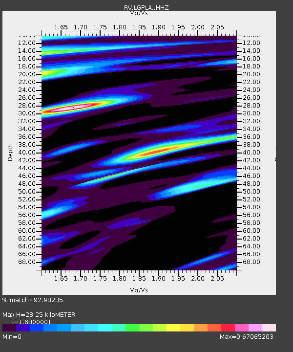
| Estimated Moho Depth: |
28.25 km |
| Estimated Crust Vp/Vs: |
1.68 |
| Assumed Crust Vp: |
6.426 km/s |
| Estimated Crust Vs: |
3.825 km/s |
| Estimated Crust Poisson's Ratio: |
0.23 |
|
| Radial Match: |
92.98235 % |
| Radial Bump: |
400 |
| Transverse Match: |
83.99958 % |
| Transverse Bump: |
400 |
| SOD ConfigId: |
30536071 |
| Insert Time: |
2023-04-01 17:43:27.604 +0000 |
| GWidth: |
2.5 |
| Max Bumps: |
400 |
| Tol: |
0.001 |
|

Signal To Noise
| Channel | StoN | STA | LTA |
| RV:LGPLA: :HHZ:20230318T17:22:43.789992Z | 7.9544263 | 1.6635269E-6 | 2.0913222E-7 |
| RV:LGPLA: :HHN:20230318T17:22:43.789992Z | 1.8899933 | 6.0234885E-7 | 3.1870422E-7 |
| RV:LGPLA: :HHE:20230318T17:22:43.789992Z | 2.4279857 | 7.199723E-7 | 2.9653071E-7 |
| Arrivals |
| Ps | 3.1 SECOND |
| PpPs | 11 SECOND |
| PsPs/PpSs | 14 SECOND |


