You are here: Home > Network List > SB - UC Santa Barbara Engineering Seismology Network () Stations List
> Station VAFB2 Taft Rd, Vandenberg AFB, CA, USA > Earthquake Result Viewer
VAFB2 Taft Rd, Vandenberg AFB, CA, USA - Earthquake Result Viewer
| Earthquake location: |
Near Coast Of Ecuador |
| Earthquake latitude/longitude: |
-2.9/-79.8 |
| Earthquake time(UTC): |
2023/03/18 (077) 17:12:53 GMT |
| Earthquake Depth: |
66 km |
| Earthquake Magnitude: |
6.7 Mww |
| Earthquake Catalog/Contributor: |
NEIC PDE/us |
|
| Network: |
SB UC Santa Barbara Engineering Seismology Network () |
| Station: |
VAFB2 Taft Rd, Vandenberg AFB, CA, USA |
| Lat/Lon: |
34.84 N/120.58 W |
| Elevation: |
91 m |
|
| Distance: |
53.6 deg |
| Az: |
318.103 deg |
| Baz: |
125.815 deg |
| Ray Param: |
0.0658356 |
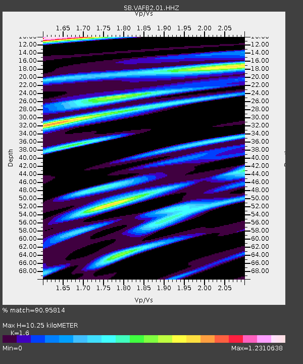
| Estimated Moho Depth: |
10.25 km |
| Estimated Crust Vp/Vs: |
1.60 |
| Assumed Crust Vp: |
6.183 km/s |
| Estimated Crust Vs: |
3.864 km/s |
| Estimated Crust Poisson's Ratio: |
0.18 |
|
| Radial Match: |
90.95814 % |
| Radial Bump: |
400 |
| Transverse Match: |
79.217384 % |
| Transverse Bump: |
400 |
| SOD ConfigId: |
30536071 |
| Insert Time: |
2023-04-01 17:43:48.556 +0000 |
| GWidth: |
2.5 |
| Max Bumps: |
400 |
| Tol: |
0.001 |
|

Signal To Noise
| Channel | StoN | STA | LTA |
| SB:VAFB2:01:HHZ:20230318T17:21:36.615004Z | 3.7703135 | 9.0031807E-7 | 2.387913E-7 |
| SB:VAFB2:01:HHN:20230318T17:21:36.615004Z | 1.7794875 | 6.969087E-7 | 3.9163453E-7 |
| SB:VAFB2:01:HHE:20230318T17:21:36.615004Z | 1.386558 | 5.4783555E-7 | 3.9510468E-7 |
| Arrivals |
| Ps | 1.1 SECOND |
| PpPs | 4.1 SECOND |
| PsPs/PpSs | 5.1 SECOND |


