You are here: Home > Network List > TX - Texas Seismological Network Stations List
> Station PB29 Culberson North > Earthquake Result Viewer
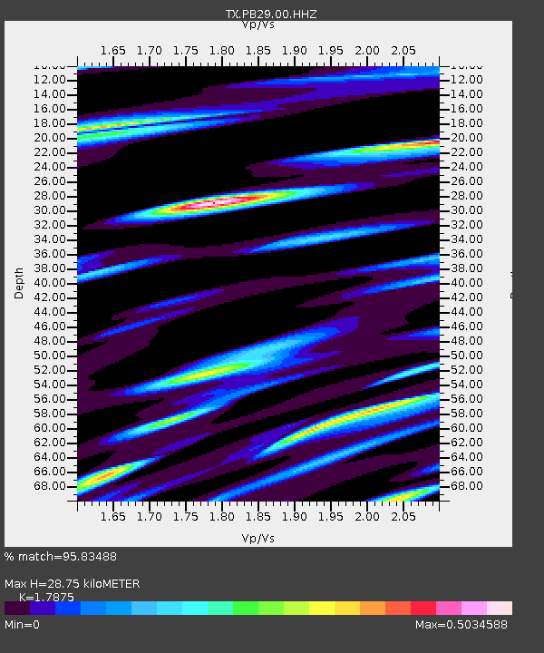
PB29 Culberson North - Earthquake Result Viewer
| Earthquake location: |
Near Coast Of Ecuador |
| Earthquake latitude/longitude: |
-2.9/-79.8 |
| Earthquake time(UTC): |
2023/03/18 (077) 17:12:53 GMT |
| Earthquake Depth: |
66 km |
| Earthquake Magnitude: |
6.7 Mww |
| Earthquake Catalog/Contributor: |
NEIC PDE/us |
|
| Network: |
TX Texas Seismological Network |
| Station: |
PB29 Culberson North |
| Lat/Lon: |
31.75 N/104.51 W |
| Elevation: |
1242 m |
|
| Distance: |
41.7 deg |
| Az: |
327.603 deg |
| Baz: |
141.085 deg |
| Ray Param: |
0.073444426 |
| Estimated Moho Depth: |
28.75 km |
| Estimated Crust Vp/Vs: |
1.79 |
| Assumed Crust Vp: |
6.361 km/s |
| Estimated Crust Vs: |
3.558 km/s |
| Estimated Crust Poisson's Ratio: |
0.27 |
|
| Radial Match: |
95.83488 % |
| Radial Bump: |
326 |
| Transverse Match: |
84.321014 % |
| Transverse Bump: |
400 |
| SOD ConfigId: |
30536071 |
| Insert Time: |
2023-04-01 17:45:35.252 +0000 |
| GWidth: |
2.5 |
| Max Bumps: |
400 |
| Tol: |
0.001 |
|

Signal To Noise
| Channel | StoN | STA | LTA |
| TX:PB29:00:HHZ:20230318T17:20:04.620009Z | 8.932945 | 1.9553734E-6 | 2.1889458E-7 |
| TX:PB29:00:HH1:20230318T17:20:04.620009Z | 4.071325 | 6.6902055E-7 | 1.6432503E-7 |
| TX:PB29:00:HH2:20230318T17:20:04.620009Z | 2.7709272 | 6.132434E-7 | 2.2131341E-7 |
| Arrivals |
| Ps | 3.8 SECOND |
| PpPs | 12 SECOND |
| PsPs/PpSs | 16 SECOND |


