You are here: Home > Network List > IU - Global Seismograph Network (GSN - IRIS/USGS) Stations List
> Station FURI Mt. Furi, Ethiopia > Earthquake Result Viewer
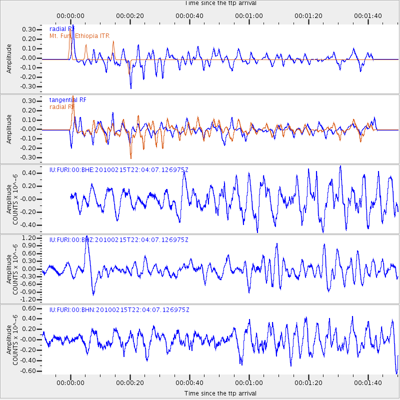
FURI Mt. Furi, Ethiopia - Earthquake Result Viewer
*The percent match for this event was below the threshold and hence no stack was calculated.
| Earthquake location: |
Banda Sea |
| Earthquake latitude/longitude: |
-7.2/128.7 |
| Earthquake time(UTC): |
2010/02/15 (046) 21:51:47 GMT |
| Earthquake Depth: |
126 km |
| Earthquake Magnitude: |
6.4 MB, 6.2 MW, 6.2 MW |
| Earthquake Catalog/Contributor: |
WHDF/NEIC |
|
| Network: |
IU Global Seismograph Network (GSN - IRIS/USGS) |
| Station: |
FURI Mt. Furi, Ethiopia |
| Lat/Lon: |
8.90 N/38.68 E |
| Elevation: |
2570 m |
|
| Distance: |
91.1 deg |
| Az: |
278.763 deg |
| Baz: |
97.078 deg |
| Ray Param: |
$rayparam |
*The percent match for this event was below the threshold and hence was not used in the summary stack. |
|
| Radial Match: |
72.56264 % |
| Radial Bump: |
383 |
| Transverse Match: |
77.12331 % |
| Transverse Bump: |
398 |
| SOD ConfigId: |
306082 |
| Insert Time: |
2010-05-06 07:35:34.601 +0000 |
| GWidth: |
2.5 |
| Max Bumps: |
400 |
| Tol: |
0.001 |
|
Signal To Noise
| Channel | StoN | STA | LTA |
| IU:FURI:00:BHZ:20100215T22:04:07.126975Z | 2.2132635 | 2.0627533E-7 | 9.319963E-8 |
| IU:FURI:00:BHN:20100215T22:04:07.126975Z | 0.5893346 | 5.076675E-8 | 8.614249E-8 |
| IU:FURI:00:BHE:20100215T22:04:07.126975Z | 0.74418545 | 9.114294E-8 | 1.2247342E-7 |
| Arrivals |
| Ps | |
| PpPs | |
| PsPs/PpSs | |


