You are here: Home > Network List > UU - University of Utah Regional Network Stations List
> Station FOR8 FORGE > Earthquake Result Viewer
FOR8 FORGE - Earthquake Result Viewer
| Earthquake location: |
Near Coast Of Ecuador |
| Earthquake latitude/longitude: |
-2.9/-79.8 |
| Earthquake time(UTC): |
2023/03/18 (077) 17:12:53 GMT |
| Earthquake Depth: |
66 km |
| Earthquake Magnitude: |
6.7 Mww |
| Earthquake Catalog/Contributor: |
NEIC PDE/us |
|
| Network: |
UU University of Utah Regional Network |
| Station: |
FOR8 FORGE |
| Lat/Lon: |
38.53 N/113.08 W |
| Elevation: |
1654 m |
|
| Distance: |
51.4 deg |
| Az: |
326.572 deg |
| Baz: |
135.452 deg |
| Ray Param: |
0.067275934 |
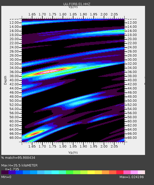
| Estimated Moho Depth: |
35.5 km |
| Estimated Crust Vp/Vs: |
1.74 |
| Assumed Crust Vp: |
6.276 km/s |
| Estimated Crust Vs: |
3.617 km/s |
| Estimated Crust Poisson's Ratio: |
0.25 |
|
| Radial Match: |
95.988434 % |
| Radial Bump: |
304 |
| Transverse Match: |
92.25286 % |
| Transverse Bump: |
400 |
| SOD ConfigId: |
30536071 |
| Insert Time: |
2023-04-01 17:49:20.904 +0000 |
| GWidth: |
2.5 |
| Max Bumps: |
400 |
| Tol: |
0.001 |
|

Signal To Noise
| Channel | StoN | STA | LTA |
| UU:FOR8:01:HHZ:20230318T17:21:20.435011Z | 10.283128 | 8.4727577E-7 | 8.2394756E-8 |
| UU:FOR8:01:HHN:20230318T17:21:20.435011Z | 2.210326 | 2.876508E-7 | 1.3013954E-7 |
| UU:FOR8:01:HHE:20230318T17:21:20.435011Z | 3.1708276 | 4.477292E-7 | 1.4120262E-7 |
| Arrivals |
| Ps | 4.4 SECOND |
| PpPs | 15 SECOND |
| PsPs/PpSs | 19 SECOND |


