You are here: Home > Network List > UU - University of Utah Regional Network Stations List
> Station MCU Monte Cristo, UT, USA > Earthquake Result Viewer
MCU Monte Cristo, UT, USA - Earthquake Result Viewer
| Earthquake location: |
Near Coast Of Ecuador |
| Earthquake latitude/longitude: |
-2.9/-79.8 |
| Earthquake time(UTC): |
2023/03/18 (077) 17:12:53 GMT |
| Earthquake Depth: |
66 km |
| Earthquake Magnitude: |
6.7 Mww |
| Earthquake Catalog/Contributor: |
NEIC PDE/us |
|
| Network: |
UU University of Utah Regional Network |
| Station: |
MCU Monte Cristo, UT, USA |
| Lat/Lon: |
41.46 N/111.51 W |
| Elevation: |
2668 m |
|
| Distance: |
52.7 deg |
| Az: |
330.223 deg |
| Baz: |
138.703 deg |
| Ray Param: |
0.06641924 |
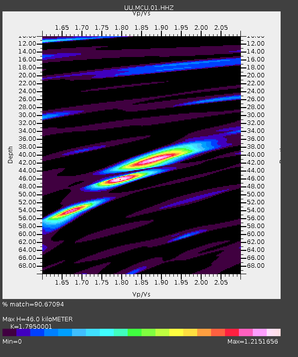
| Estimated Moho Depth: |
46.0 km |
| Estimated Crust Vp/Vs: |
1.80 |
| Assumed Crust Vp: |
6.155 km/s |
| Estimated Crust Vs: |
3.429 km/s |
| Estimated Crust Poisson's Ratio: |
0.27 |
|
| Radial Match: |
90.67094 % |
| Radial Bump: |
400 |
| Transverse Match: |
75.23558 % |
| Transverse Bump: |
400 |
| SOD ConfigId: |
30536071 |
| Insert Time: |
2023-04-01 17:49:34.210 +0000 |
| GWidth: |
2.5 |
| Max Bumps: |
400 |
| Tol: |
0.001 |
|

Signal To Noise
| Channel | StoN | STA | LTA |
| UU:MCU:01:HHZ:20230318T17:21:30.260023Z | 8.384504 | 1.2280314E-6 | 1.464644E-7 |
| UU:MCU:01:HHN:20230318T17:21:30.260023Z | 3.3294063 | 3.3370972E-7 | 1.00231006E-7 |
| UU:MCU:01:HHE:20230318T17:21:30.260023Z | 4.7564626 | 5.495385E-7 | 1.1553514E-7 |
| Arrivals |
| Ps | 6.2 SECOND |
| PpPs | 20 SECOND |
| PsPs/PpSs | 26 SECOND |


