You are here: Home > Network List > UW - Pacific Northwest Regional Seismic Network Stations List
> Station ANGUS Elk Ridge Ranch, WA, USA > Earthquake Result Viewer
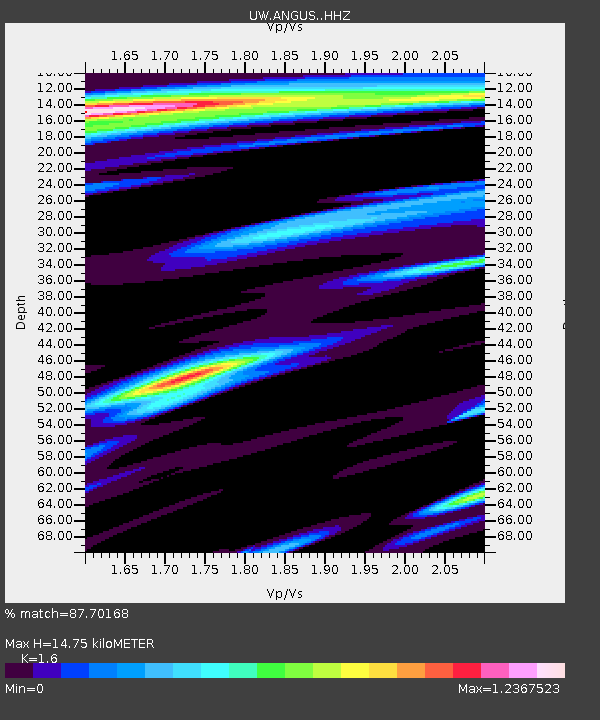
ANGUS Elk Ridge Ranch, WA, USA - Earthquake Result Viewer
| Earthquake location: |
Near Coast Of Ecuador |
| Earthquake latitude/longitude: |
-2.9/-79.8 |
| Earthquake time(UTC): |
2023/03/18 (077) 17:12:53 GMT |
| Earthquake Depth: |
66 km |
| Earthquake Magnitude: |
6.7 Mww |
| Earthquake Catalog/Contributor: |
NEIC PDE/us |
|
| Network: |
UW Pacific Northwest Regional Seismic Network |
| Station: |
ANGUS Elk Ridge Ranch, WA, USA |
| Lat/Lon: |
47.10 N/123.49 W |
| Elevation: |
90 m |
|
| Distance: |
62.8 deg |
| Az: |
327.951 deg |
| Baz: |
129.121 deg |
| Ray Param: |
0.05983663 |
| Estimated Moho Depth: |
14.75 km |
| Estimated Crust Vp/Vs: |
1.60 |
| Assumed Crust Vp: |
6.566 km/s |
| Estimated Crust Vs: |
4.104 km/s |
| Estimated Crust Poisson's Ratio: |
0.18 |
|
| Radial Match: |
87.70168 % |
| Radial Bump: |
400 |
| Transverse Match: |
82.61391 % |
| Transverse Bump: |
371 |
| SOD ConfigId: |
30536071 |
| Insert Time: |
2023-04-01 17:49:48.100 +0000 |
| GWidth: |
2.5 |
| Max Bumps: |
400 |
| Tol: |
0.001 |
|

Signal To Noise
| Channel | StoN | STA | LTA |
| UW:ANGUS: :HHZ:20230318T17:22:40.859999Z | 5.123698 | 1.1485599E-6 | 2.241662E-7 |
| UW:ANGUS: :HHN:20230318T17:22:40.859999Z | 0.575331 | 2.5193557E-7 | 4.3789677E-7 |
| UW:ANGUS: :HHE:20230318T17:22:40.859999Z | 1.542981 | 5.6667744E-7 | 3.6726144E-7 |
| Arrivals |
| Ps | 1.4 SECOND |
| PpPs | 5.5 SECOND |
| PsPs/PpSs | 7.0 SECOND |


