You are here: Home > Network List > UW - Pacific Northwest Regional Seismic Network Stations List
> Station BLOW BLOW, Detroit Lake, OR, USA > Earthquake Result Viewer
BLOW BLOW, Detroit Lake, OR, USA - Earthquake Result Viewer

| Earthquake location: |
Near Coast Of Ecuador |
| Earthquake latitude/longitude: |
-2.9/-79.8 |
| Earthquake time(UTC): |
2023/03/18 (077) 17:12:53 GMT |
| Earthquake Depth: |
66 km |
| Earthquake Magnitude: |
6.7 Mww |
| Earthquake Catalog/Contributor: |
NEIC PDE/us |
|
| Network: |
UW Pacific Northwest Regional Seismic Network |
| Station: |
BLOW BLOW, Detroit Lake, OR, USA |
| Lat/Lon: |
44.68 N/122.19 W |
| Elevation: |
657 m |
|
| Distance: |
60.6 deg |
| Az: |
326.479 deg |
| Baz: |
129.358 deg |
| Ray Param: |
0.06130298 |
| Estimated Moho Depth: |
10.0 km |
| Estimated Crust Vp/Vs: |
2.07 |
| Assumed Crust Vp: |
6.566 km/s |
| Estimated Crust Vs: |
3.176 km/s |
| Estimated Crust Poisson's Ratio: |
0.35 |
|
| Radial Match: |
90.48448 % |
| Radial Bump: |
400 |
| Transverse Match: |
81.58693 % |
| Transverse Bump: |
400 |
| SOD ConfigId: |
30536071 |
| Insert Time: |
2023-04-01 17:50:01.363 +0000 |
| GWidth: |
2.5 |
| Max Bumps: |
400 |
| Tol: |
0.001 |
|
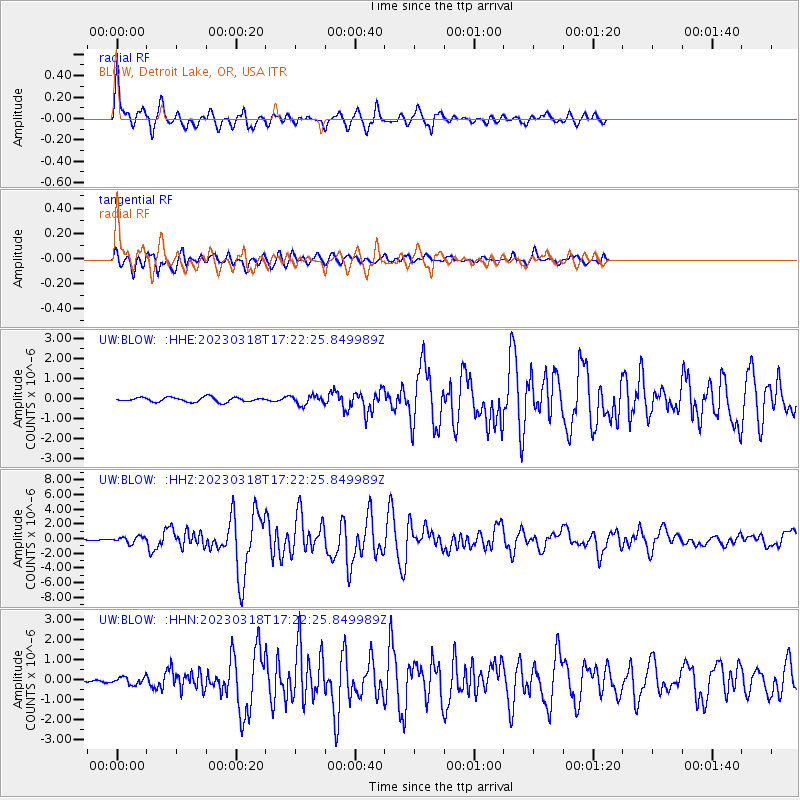
Signal To Noise
| Channel | StoN | STA | LTA |
| UW:BLOW: :HHZ:20230318T17:22:25.849989Z | 5.296236 | 4.4094293E-7 | 8.3255905E-8 |
| UW:BLOW: :HHN:20230318T17:22:25.849989Z | 1.9876134 | 1.8328237E-7 | 9.221228E-8 |
| UW:BLOW: :HHE:20230318T17:22:25.849989Z | 1.9318262 | 2.1955667E-7 | 1.1365239E-7 |
| Arrivals |
| Ps | 1.7 SECOND |
| PpPs | 4.5 SECOND |
| PsPs/PpSs | 6.2 SECOND |


