You are here: Home > Network List > UW - Pacific Northwest Regional Seismic Network Stations List
> Station FISH2 Jewell, OR, USA > Earthquake Result Viewer
FISH2 Jewell, OR, USA - Earthquake Result Viewer
| Earthquake location: |
Near Coast Of Ecuador |
| Earthquake latitude/longitude: |
-2.9/-79.8 |
| Earthquake time(UTC): |
2023/03/18 (077) 17:12:53 GMT |
| Earthquake Depth: |
66 km |
| Earthquake Magnitude: |
6.7 Mww |
| Earthquake Catalog/Contributor: |
NEIC PDE/us |
|
| Network: |
UW Pacific Northwest Regional Seismic Network |
| Station: |
FISH2 Jewell, OR, USA |
| Lat/Lon: |
45.93 N/123.50 W |
| Elevation: |
146 m |
|
| Distance: |
62.1 deg |
| Az: |
326.916 deg |
| Baz: |
128.638 deg |
| Ray Param: |
0.060319625 |
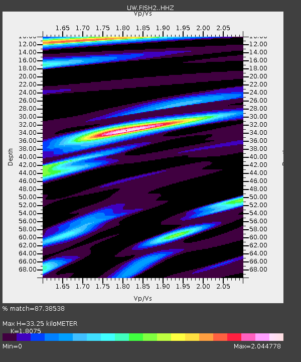
| Estimated Moho Depth: |
33.25 km |
| Estimated Crust Vp/Vs: |
1.81 |
| Assumed Crust Vp: |
6.566 km/s |
| Estimated Crust Vs: |
3.633 km/s |
| Estimated Crust Poisson's Ratio: |
0.28 |
|
| Radial Match: |
87.38538 % |
| Radial Bump: |
400 |
| Transverse Match: |
76.15847 % |
| Transverse Bump: |
400 |
| SOD ConfigId: |
30536071 |
| Insert Time: |
2023-04-01 17:50:49.040 +0000 |
| GWidth: |
2.5 |
| Max Bumps: |
400 |
| Tol: |
0.001 |
|

Signal To Noise
| Channel | StoN | STA | LTA |
| UW:FISH2: :HHZ:20230318T17:22:35.979994Z | 7.0413055 | 6.482618E-7 | 9.206557E-8 |
| UW:FISH2: :HHN:20230318T17:22:35.979994Z | 1.2062916 | 3.8734248E-7 | 3.2110188E-7 |
| UW:FISH2: :HHE:20230318T17:22:35.979994Z | 1.1548027 | 2.8701672E-7 | 2.485418E-7 |
| Arrivals |
| Ps | 4.3 SECOND |
| PpPs | 14 SECOND |
| PsPs/PpSs | 18 SECOND |


