You are here: Home > Network List > UW - Pacific Northwest Regional Seismic Network Stations List
> Station HERD Green Diamond Tree Farm, Grays Harbor County, WA, USA > Earthquake Result Viewer
HERD Green Diamond Tree Farm, Grays Harbor County, WA, USA - Earthquake Result Viewer
| Earthquake location: |
Near Coast Of Ecuador |
| Earthquake latitude/longitude: |
-2.9/-79.8 |
| Earthquake time(UTC): |
2023/03/18 (077) 17:12:53 GMT |
| Earthquake Depth: |
66 km |
| Earthquake Magnitude: |
6.7 Mww |
| Earthquake Catalog/Contributor: |
NEIC PDE/us |
|
| Network: |
UW Pacific Northwest Regional Seismic Network |
| Station: |
HERD Green Diamond Tree Farm, Grays Harbor County, WA, USA |
| Lat/Lon: |
47.23 N/123.65 W |
| Elevation: |
178 m |
|
| Distance: |
63.0 deg |
| Az: |
327.984 deg |
| Baz: |
129.019 deg |
| Ray Param: |
0.05973762 |
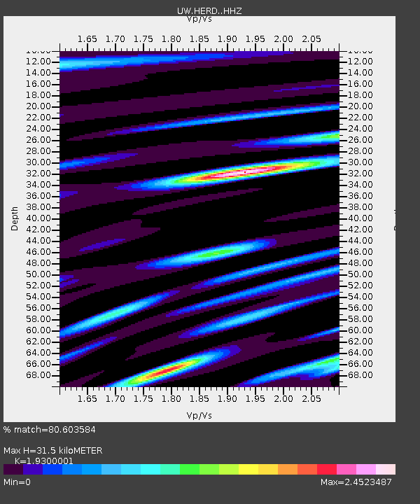
| Estimated Moho Depth: |
31.5 km |
| Estimated Crust Vp/Vs: |
1.93 |
| Assumed Crust Vp: |
6.566 km/s |
| Estimated Crust Vs: |
3.402 km/s |
| Estimated Crust Poisson's Ratio: |
0.32 |
|
| Radial Match: |
80.603584 % |
| Radial Bump: |
400 |
| Transverse Match: |
85.73809 % |
| Transverse Bump: |
400 |
| SOD ConfigId: |
30536071 |
| Insert Time: |
2023-04-01 17:51:07.800 +0000 |
| GWidth: |
2.5 |
| Max Bumps: |
400 |
| Tol: |
0.001 |
|

Signal To Noise
| Channel | StoN | STA | LTA |
| UW:HERD: :HHZ:20230318T17:22:41.950026Z | 3.146268 | 6.4233546E-7 | 2.0415791E-7 |
| UW:HERD: :HHN:20230318T17:22:41.950026Z | 1.3401284 | 3.276017E-7 | 2.4445546E-7 |
| UW:HERD: :HHE:20230318T17:22:41.950026Z | 1.0513377 | 2.6112448E-7 | 2.4837354E-7 |
| Arrivals |
| Ps | 4.7 SECOND |
| PpPs | 13 SECOND |
| PsPs/PpSs | 18 SECOND |


