You are here: Home > Network List > UW - Pacific Northwest Regional Seismic Network Stations List
> Station LOKMT Lookout Mt, WA, USA > Earthquake Result Viewer
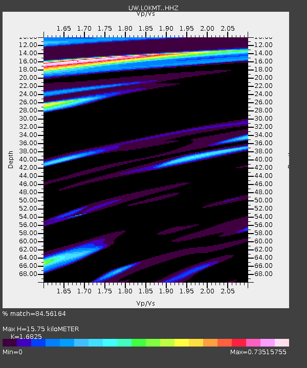
LOKMT Lookout Mt, WA, USA - Earthquake Result Viewer
| Earthquake location: |
Near Coast Of Ecuador |
| Earthquake latitude/longitude: |
-2.9/-79.8 |
| Earthquake time(UTC): |
2023/03/18 (077) 17:12:53 GMT |
| Earthquake Depth: |
66 km |
| Earthquake Magnitude: |
6.7 Mww |
| Earthquake Catalog/Contributor: |
NEIC PDE/us |
|
| Network: |
UW Pacific Northwest Regional Seismic Network |
| Station: |
LOKMT Lookout Mt, WA, USA |
| Lat/Lon: |
47.15 N/120.79 W |
| Elevation: |
824 m |
|
| Distance: |
61.4 deg |
| Az: |
329.347 deg |
| Baz: |
131.75 deg |
| Ray Param: |
0.06073317 |
| Estimated Moho Depth: |
15.75 km |
| Estimated Crust Vp/Vs: |
1.68 |
| Assumed Crust Vp: |
6.597 km/s |
| Estimated Crust Vs: |
3.921 km/s |
| Estimated Crust Poisson's Ratio: |
0.23 |
|
| Radial Match: |
84.56164 % |
| Radial Bump: |
369 |
| Transverse Match: |
79.499405 % |
| Transverse Bump: |
400 |
| SOD ConfigId: |
30536071 |
| Insert Time: |
2023-04-01 17:51:45.884 +0000 |
| GWidth: |
2.5 |
| Max Bumps: |
400 |
| Tol: |
0.001 |
|

Signal To Noise
| Channel | StoN | STA | LTA |
| UW:LOKMT: :HHZ:20230318T17:22:31.690016Z | 2.6750462 | 1.010009E-6 | 3.7756692E-7 |
| UW:LOKMT: :HHN:20230318T17:22:31.690016Z | 2.0567563 | 5.186784E-7 | 2.5218276E-7 |
| UW:LOKMT: :HHE:20230318T17:22:31.690016Z | 1.6751753 | 5.956558E-7 | 3.555782E-7 |
| Arrivals |
| Ps | 1.7 SECOND |
| PpPs | 6.1 SECOND |
| PsPs/PpSs | 7.8 SECOND |


