You are here: Home > Network List > UW - Pacific Northwest Regional Seismic Network Stations List
> Station VFP Flag Point, OR, USA > Earthquake Result Viewer
VFP Flag Point, OR, USA - Earthquake Result Viewer
| Earthquake location: |
Near Coast Of Ecuador |
| Earthquake latitude/longitude: |
-2.9/-79.8 |
| Earthquake time(UTC): |
2023/03/18 (077) 17:12:53 GMT |
| Earthquake Depth: |
66 km |
| Earthquake Magnitude: |
6.7 Mww |
| Earthquake Catalog/Contributor: |
NEIC PDE/us |
|
| Network: |
UW Pacific Northwest Regional Seismic Network |
| Station: |
VFP Flag Point, OR, USA |
| Lat/Lon: |
45.32 N/121.47 W |
| Elevation: |
1722 m |
|
| Distance: |
60.6 deg |
| Az: |
327.414 deg |
| Baz: |
130.325 deg |
| Ray Param: |
0.061293483 |
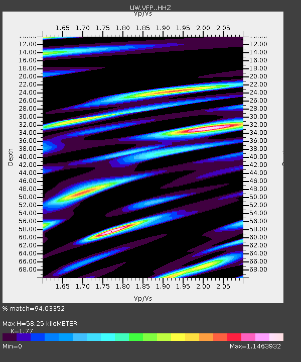
| Estimated Moho Depth: |
58.25 km |
| Estimated Crust Vp/Vs: |
1.77 |
| Assumed Crust Vp: |
6.597 km/s |
| Estimated Crust Vs: |
3.727 km/s |
| Estimated Crust Poisson's Ratio: |
0.27 |
|
| Radial Match: |
94.03352 % |
| Radial Bump: |
400 |
| Transverse Match: |
92.61861 % |
| Transverse Bump: |
400 |
| SOD ConfigId: |
30536071 |
| Insert Time: |
2023-04-01 17:53:26.129 +0000 |
| GWidth: |
2.5 |
| Max Bumps: |
400 |
| Tol: |
0.001 |
|

Signal To Noise
| Channel | StoN | STA | LTA |
| UW:VFP: :HHZ:20230318T17:22:25.950026Z | 7.974113 | 8.3339575E-7 | 1.0451266E-7 |
| UW:VFP: :HHN:20230318T17:22:25.950026Z | 2.4440403 | 3.9059458E-7 | 1.5981512E-7 |
| UW:VFP: :HHE:20230318T17:22:25.950026Z | 3.8535018 | 5.0932994E-7 | 1.3217327E-7 |
| Arrivals |
| Ps | 7.1 SECOND |
| PpPs | 23 SECOND |
| PsPs/PpSs | 30 SECOND |


