You are here: Home > Network List > UW - Pacific Northwest Regional Seismic Network Stations List
> Station WPEQ White Pass Ski Facility, WA, USA > Earthquake Result Viewer
WPEQ White Pass Ski Facility, WA, USA - Earthquake Result Viewer
| Earthquake location: |
Near Coast Of Ecuador |
| Earthquake latitude/longitude: |
-2.9/-79.8 |
| Earthquake time(UTC): |
2023/03/18 (077) 17:12:53 GMT |
| Earthquake Depth: |
66 km |
| Earthquake Magnitude: |
6.7 Mww |
| Earthquake Catalog/Contributor: |
NEIC PDE/us |
|
| Network: |
UW Pacific Northwest Regional Seismic Network |
| Station: |
WPEQ White Pass Ski Facility, WA, USA |
| Lat/Lon: |
46.61 N/121.40 W |
| Elevation: |
1807 m |
|
| Distance: |
61.4 deg |
| Az: |
328.571 deg |
| Baz: |
130.931 deg |
| Ray Param: |
0.060756013 |
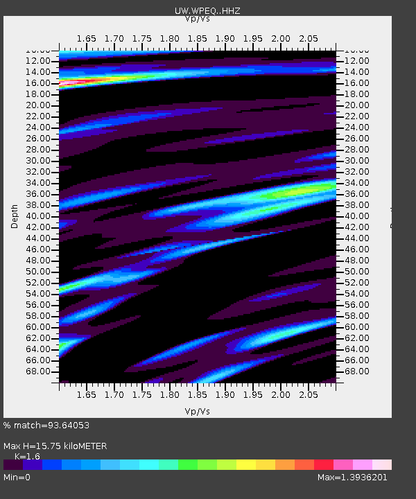
| Estimated Moho Depth: |
15.75 km |
| Estimated Crust Vp/Vs: |
1.60 |
| Assumed Crust Vp: |
6.597 km/s |
| Estimated Crust Vs: |
4.123 km/s |
| Estimated Crust Poisson's Ratio: |
0.18 |
|
| Radial Match: |
93.64053 % |
| Radial Bump: |
400 |
| Transverse Match: |
88.38226 % |
| Transverse Bump: |
400 |
| SOD ConfigId: |
30536071 |
| Insert Time: |
2023-04-01 17:53:35.647 +0000 |
| GWidth: |
2.5 |
| Max Bumps: |
400 |
| Tol: |
0.001 |
|

Signal To Noise
| Channel | StoN | STA | LTA |
| UW:WPEQ: :HHZ:20230318T17:22:31.430006Z | 2.7348711 | 4.3977576E-7 | 1.6080311E-7 |
| UW:WPEQ: :HHN:20230318T17:22:31.430006Z | 1.0829588 | 2.3287497E-7 | 2.1503585E-7 |
| UW:WPEQ: :HHE:20230318T17:22:31.430006Z | 1.3838991 | 2.7051678E-7 | 1.9547436E-7 |
| Arrivals |
| Ps | 1.5 SECOND |
| PpPs | 5.9 SECOND |
| PsPs/PpSs | 7.4 SECOND |


