You are here: Home > Network List > IW - Intermountain West Stations List
> Station MOOW Moose Ponds, Wyoming, USA > Earthquake Result Viewer
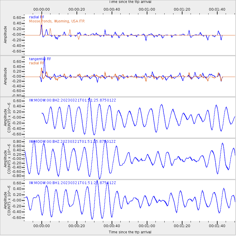
MOOW Moose Ponds, Wyoming, USA - Earthquake Result Viewer
*The percent match for this event was below the threshold and hence no stack was calculated.
| Earthquake location: |
Costa Rica |
| Earthquake latitude/longitude: |
9.4/-84.1 |
| Earthquake time(UTC): |
2023/03/21 (080) 01:44:13 GMT |
| Earthquake Depth: |
35 km |
| Earthquake Magnitude: |
5.5 mww |
| Earthquake Catalog/Contributor: |
NEIC PDE/us |
|
| Network: |
IW Intermountain West |
| Station: |
MOOW Moose Ponds, Wyoming, USA |
| Lat/Lon: |
43.75 N/110.74 W |
| Elevation: |
2128 m |
|
| Distance: |
41.4 deg |
| Az: |
330.535 deg |
| Baz: |
137.945 deg |
| Ray Param: |
$rayparam |
*The percent match for this event was below the threshold and hence was not used in the summary stack. |
|
| Radial Match: |
63.88651 % |
| Radial Bump: |
400 |
| Transverse Match: |
83.45877 % |
| Transverse Bump: |
400 |
| SOD ConfigId: |
30536071 |
| Insert Time: |
2023-04-04 01:56:33.427 +0000 |
| GWidth: |
2.5 |
| Max Bumps: |
400 |
| Tol: |
0.001 |
|
Signal To Noise
| Channel | StoN | STA | LTA |
| IW:MOOW:00:BHZ:20230321T01:51:25.875012Z | 1.8803202 | 4.522476E-7 | 2.4051627E-7 |
| IW:MOOW:00:BH1:20230321T01:51:25.875012Z | 2.3203788 | 3.4815272E-7 | 1.5004133E-7 |
| IW:MOOW:00:BH2:20230321T01:51:25.875012Z | 1.3535637 | 3.9521498E-7 | 2.9198108E-7 |
| Arrivals |
| Ps | |
| PpPs | |
| PsPs/PpSs | |


