You are here: Home > Network List > 1E - GSC-BCOGC Induced Seismicity Study Stations List
> Station MONT2 Z > Earthquake Result Viewer
MONT2 Z - Earthquake Result Viewer
| Earthquake location: |
Hindu Kush Region, Afghanistan |
| Earthquake latitude/longitude: |
36.5/71.0 |
| Earthquake time(UTC): |
2023/03/21 (080) 16:47:23 GMT |
| Earthquake Depth: |
188 km |
| Earthquake Magnitude: |
6.5 Mww |
| Earthquake Catalog/Contributor: |
NEIC PDE/us |
|
| Network: |
1E GSC-BCOGC Induced Seismicity Study |
| Station: |
MONT2 Z |
| Lat/Lon: |
56.02 N/120.05 W |
| Elevation: |
642 m |
|
| Distance: |
87.3 deg |
| Az: |
6.171 deg |
| Baz: |
351.128 deg |
| Ray Param: |
0.042965088 |
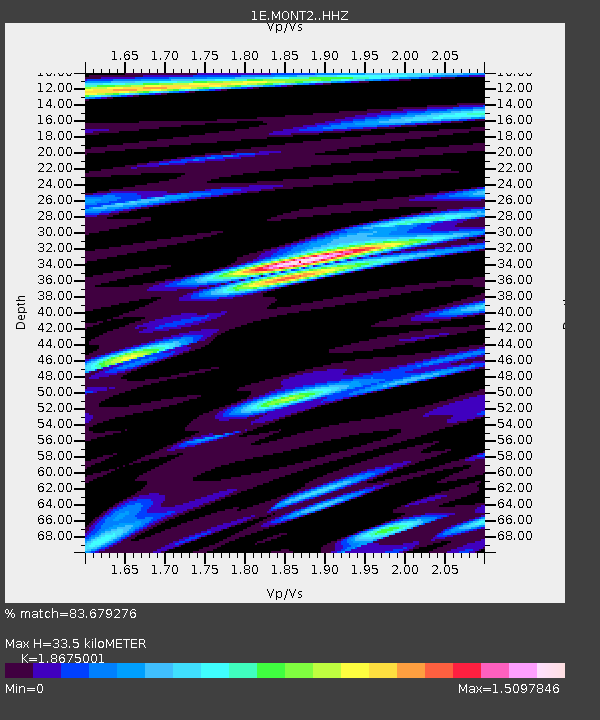
| Estimated Moho Depth: |
33.5 km |
| Estimated Crust Vp/Vs: |
1.87 |
| Assumed Crust Vp: |
6.291 km/s |
| Estimated Crust Vs: |
3.369 km/s |
| Estimated Crust Poisson's Ratio: |
0.30 |
|
| Radial Match: |
83.679276 % |
| Radial Bump: |
400 |
| Transverse Match: |
75.3651 % |
| Transverse Bump: |
400 |
| SOD ConfigId: |
30536071 |
| Insert Time: |
2023-04-04 16:48:06.525 +0000 |
| GWidth: |
2.5 |
| Max Bumps: |
400 |
| Tol: |
0.001 |
|

Signal To Noise
| Channel | StoN | STA | LTA |
| 1E:MONT2: :HHZ:20230321T16:59:18.09002Z | 20.083544 | 8.23988E-6 | 4.102802E-7 |
| 1E:MONT2: :HHN:20230321T16:59:18.09002Z | 3.8125193 | 2.4342664E-6 | 6.3849285E-7 |
| 1E:MONT2: :HHE:20230321T16:59:18.09002Z | 2.1997292 | 1.307445E-6 | 5.943663E-7 |
| Arrivals |
| Ps | 4.7 SECOND |
| PpPs | 15 SECOND |
| PsPs/PpSs | 20 SECOND |


