You are here: Home > Network List > 1E - GSC-BCOGC Induced Seismicity Study Stations List
> Station MONT4 Z > Earthquake Result Viewer
MONT4 Z - Earthquake Result Viewer
| Earthquake location: |
Hindu Kush Region, Afghanistan |
| Earthquake latitude/longitude: |
36.5/71.0 |
| Earthquake time(UTC): |
2023/03/21 (080) 16:47:23 GMT |
| Earthquake Depth: |
188 km |
| Earthquake Magnitude: |
6.5 Mww |
| Earthquake Catalog/Contributor: |
NEIC PDE/us |
|
| Network: |
1E GSC-BCOGC Induced Seismicity Study |
| Station: |
MONT4 Z |
| Lat/Lon: |
57.32 N/122.71 W |
| Elevation: |
1110 m |
|
| Distance: |
85.8 deg |
| Az: |
7.394 deg |
| Baz: |
348.984 deg |
| Ray Param: |
0.04407043 |
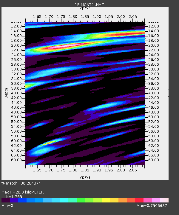
| Estimated Moho Depth: |
20.0 km |
| Estimated Crust Vp/Vs: |
1.76 |
| Assumed Crust Vp: |
6.232 km/s |
| Estimated Crust Vs: |
3.531 km/s |
| Estimated Crust Poisson's Ratio: |
0.26 |
|
| Radial Match: |
80.284874 % |
| Radial Bump: |
400 |
| Transverse Match: |
72.14159 % |
| Transverse Bump: |
400 |
| SOD ConfigId: |
30536071 |
| Insert Time: |
2023-04-04 16:48:09.623 +0000 |
| GWidth: |
2.5 |
| Max Bumps: |
400 |
| Tol: |
0.001 |
|

Signal To Noise
| Channel | StoN | STA | LTA |
| 1E:MONT4: :HHZ:20230321T16:59:10.669976Z | 22.285488 | 7.736756E-6 | 3.4716564E-7 |
| 1E:MONT4: :HHN:20230321T16:59:10.669976Z | 4.7946296 | 2.2591455E-6 | 4.7118246E-7 |
| 1E:MONT4: :HHE:20230321T16:59:10.669976Z | 6.1021194 | 1.4239617E-6 | 2.3335528E-7 |
| Arrivals |
| Ps | 2.5 SECOND |
| PpPs | 8.7 SECOND |
| PsPs/PpSs | 11 SECOND |


