You are here: Home > Network List > CI - Caltech Regional Seismic Network Stations List
> Station IRM Iron Mountain Pumping Station, Eagle Mtn., CA, USA > Earthquake Result Viewer
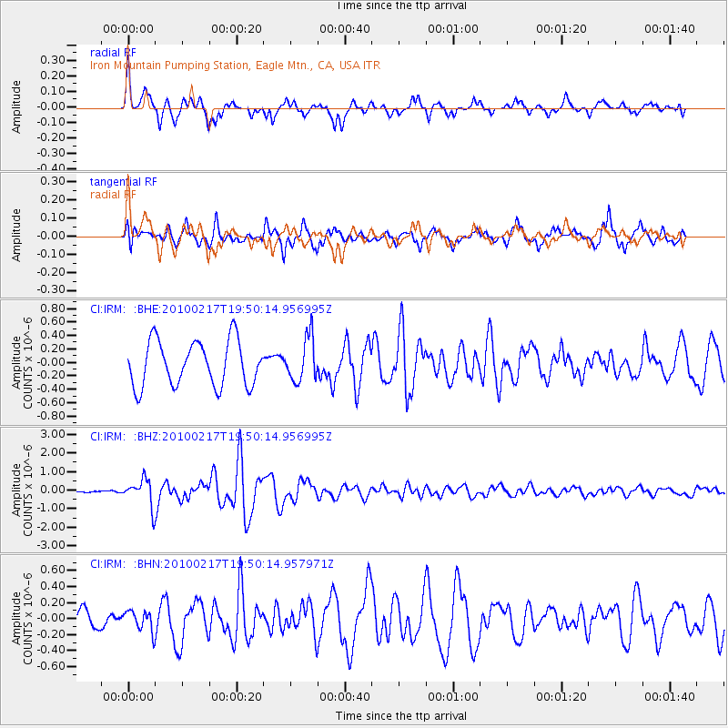
IRM Iron Mountain Pumping Station, Eagle Mtn., CA, USA - Earthquake Result Viewer
*The percent match for this event was below the threshold and hence no stack was calculated.
| Earthquake location: |
Kermadec Islands, New Zealand |
| Earthquake latitude/longitude: |
-29.8/-177.8 |
| Earthquake time(UTC): |
2010/02/17 (048) 19:38:06 GMT |
| Earthquake Depth: |
45 km |
| Earthquake Magnitude: |
5.8 MB, 5.5 MS, 5.9 MW, 5.9 MW |
| Earthquake Catalog/Contributor: |
WHDF/NEIC |
|
| Network: |
CI Caltech Regional Seismic Network |
| Station: |
IRM Iron Mountain Pumping Station, Eagle Mtn., CA, USA |
| Lat/Lon: |
34.16 N/115.15 W |
| Elevation: |
567 m |
|
| Distance: |
86.9 deg |
| Az: |
47.555 deg |
| Baz: |
230.698 deg |
| Ray Param: |
$rayparam |
*The percent match for this event was below the threshold and hence was not used in the summary stack. |
|
| Radial Match: |
65.63835 % |
| Radial Bump: |
358 |
| Transverse Match: |
69.41453 % |
| Transverse Bump: |
400 |
| SOD ConfigId: |
306082 |
| Insert Time: |
2010-05-06 07:44:31.516 +0000 |
| GWidth: |
2.5 |
| Max Bumps: |
400 |
| Tol: |
0.001 |
|
Signal To Noise
| Channel | StoN | STA | LTA |
| CI:IRM: :BHZ:20100217T19:50:14.956995Z | 3.8795319 | 7.2708593E-7 | 1.8741589E-7 |
| CI:IRM: :BHN:20100217T19:50:14.957971Z | 1.0811868 | 1.2791247E-7 | 1.1830747E-7 |
| CI:IRM: :BHE:20100217T19:50:14.956995Z | 0.98867035 | 3.302439E-7 | 3.3402833E-7 |
| Arrivals |
| Ps | |
| PpPs | |
| PsPs/PpSs | |


