You are here: Home > Network List > AK - Alaska Regional Network Stations List
> Station MDM Murphy Dome > Earthquake Result Viewer
MDM Murphy Dome - Earthquake Result Viewer
| Earthquake location: |
Hindu Kush Region, Afghanistan |
| Earthquake latitude/longitude: |
36.5/71.0 |
| Earthquake time(UTC): |
2023/03/21 (080) 16:47:23 GMT |
| Earthquake Depth: |
188 km |
| Earthquake Magnitude: |
6.5 Mww |
| Earthquake Catalog/Contributor: |
NEIC PDE/us |
|
| Network: |
AK Alaska Regional Network |
| Station: |
MDM Murphy Dome |
| Lat/Lon: |
64.96 N/148.23 W |
| Elevation: |
634 m |
|
| Distance: |
74.3 deg |
| Az: |
16.228 deg |
| Baz: |
328.067 deg |
| Ray Param: |
0.05193535 |
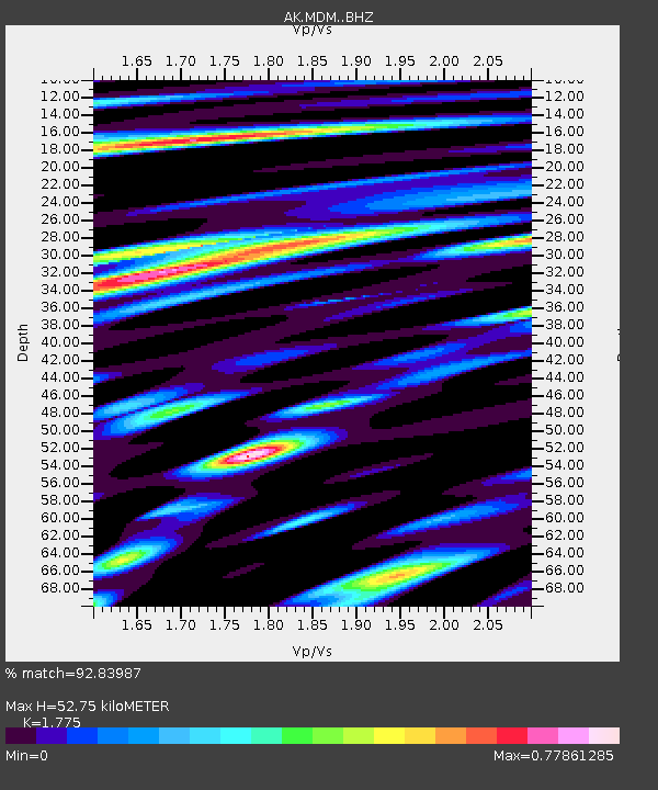
| Estimated Moho Depth: |
52.75 km |
| Estimated Crust Vp/Vs: |
1.77 |
| Assumed Crust Vp: |
6.566 km/s |
| Estimated Crust Vs: |
3.699 km/s |
| Estimated Crust Poisson's Ratio: |
0.27 |
|
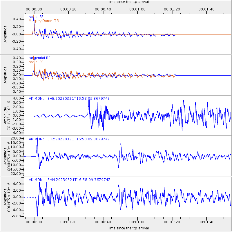
| Radial Match: |
92.83987 % |
| Radial Bump: |
400 |
| Transverse Match: |
88.62989 % |
| Transverse Bump: |
400 |
| SOD ConfigId: |
30536071 |
| Insert Time: |
2023-04-04 16:51:35.389 +0000 |
| GWidth: |
2.5 |
| Max Bumps: |
400 |
| Tol: |
0.001 |
|
Signal To Noise
| Channel | StoN | STA | LTA |
| AK:MDM: :BHZ:20230321T16:58:09.367974Z | 42.79974 | 7.7541135E-6 | 1.8117198E-7 |
| AK:MDM: :BHN:20230321T16:58:09.367974Z | 15.98243 | 2.1712044E-6 | 1.3584946E-7 |
| AK:MDM: :BHE:20230321T16:58:09.367974Z | 7.9118814 | 1.562746E-6 | 1.9751889E-7 |
| Arrivals |
| Ps | 6.4 SECOND |
| PpPs | 22 SECOND |
| PsPs/PpSs | 28 SECOND |


