You are here: Home > Network List > AV - Alaska Volcano Observatory Stations List
> Station SPNN North Nagishlamina, Mount Spurr, Alaska > Earthquake Result Viewer
SPNN North Nagishlamina, Mount Spurr, Alaska - Earthquake Result Viewer
| Earthquake location: |
Hindu Kush Region, Afghanistan |
| Earthquake latitude/longitude: |
36.5/71.0 |
| Earthquake time(UTC): |
2023/03/21 (080) 16:47:23 GMT |
| Earthquake Depth: |
188 km |
| Earthquake Magnitude: |
6.5 Mww |
| Earthquake Catalog/Contributor: |
NEIC PDE/us |
|
| Network: |
AV Alaska Volcano Observatory |
| Station: |
SPNN North Nagishlamina, Mount Spurr, Alaska |
| Lat/Lon: |
61.37 N/152.70 W |
| Elevation: |
1666 m |
|
| Distance: |
76.2 deg |
| Az: |
20.034 deg |
| Baz: |
325.049 deg |
| Ray Param: |
0.050679676 |
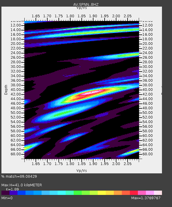
| Estimated Moho Depth: |
41.0 km |
| Estimated Crust Vp/Vs: |
1.89 |
| Assumed Crust Vp: |
6.566 km/s |
| Estimated Crust Vs: |
3.474 km/s |
| Estimated Crust Poisson's Ratio: |
0.31 |
|
| Radial Match: |
89.08429 % |
| Radial Bump: |
400 |
| Transverse Match: |
87.92922 % |
| Transverse Bump: |
400 |
| SOD ConfigId: |
30536071 |
| Insert Time: |
2023-04-04 16:56:43.584 +0000 |
| GWidth: |
2.5 |
| Max Bumps: |
400 |
| Tol: |
0.001 |
|

Signal To Noise
| Channel | StoN | STA | LTA |
| AV:SPNN: :BHZ:20230321T16:58:20.140007Z | 19.025227 | 5.0775852E-6 | 2.6688696E-7 |
| AV:SPNN: :BHN:20230321T16:58:20.140007Z | 8.287989 | 1.9612557E-6 | 2.3663833E-7 |
| AV:SPNN: :BHE:20230321T16:58:20.140007Z | 4.562032 | 1.3746956E-6 | 3.01334E-7 |
| Arrivals |
| Ps | 5.7 SECOND |
| PpPs | 18 SECOND |
| PsPs/PpSs | 23 SECOND |


