You are here: Home > Network List > TA - USArray Transportable Network (new EarthScope stations) Stations List
> Station J21A Lysite, WY, USA > Earthquake Result Viewer
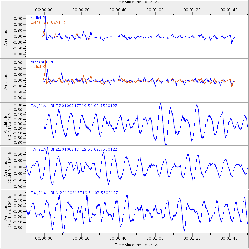
J21A Lysite, WY, USA - Earthquake Result Viewer
*The percent match for this event was below the threshold and hence no stack was calculated.
| Earthquake location: |
Kermadec Islands, New Zealand |
| Earthquake latitude/longitude: |
-29.8/-177.8 |
| Earthquake time(UTC): |
2010/02/17 (048) 19:38:06 GMT |
| Earthquake Depth: |
45 km |
| Earthquake Magnitude: |
5.8 MB, 5.5 MS, 5.9 MW, 5.9 MW |
| Earthquake Catalog/Contributor: |
WHDF/NEIC |
|
| Network: |
TA USArray Transportable Network (new EarthScope stations) |
| Station: |
J21A Lysite, WY, USA |
| Lat/Lon: |
43.35 N/107.45 W |
| Elevation: |
1913 m |
|
| Distance: |
97.2 deg |
| Az: |
43.838 deg |
| Baz: |
235.649 deg |
| Ray Param: |
$rayparam |
*The percent match for this event was below the threshold and hence was not used in the summary stack. |
|
| Radial Match: |
75.12404 % |
| Radial Bump: |
390 |
| Transverse Match: |
46.390354 % |
| Transverse Bump: |
400 |
| SOD ConfigId: |
306082 |
| Insert Time: |
2010-05-06 07:48:54.306 +0000 |
| GWidth: |
2.5 |
| Max Bumps: |
400 |
| Tol: |
0.001 |
|
Signal To Noise
| Channel | StoN | STA | LTA |
| TA:J21A: :BHZ:20100217T19:51:02.550012Z | 2.0768416 | 5.742522E-7 | 2.7650267E-7 |
| TA:J21A: :BHN:20100217T19:51:02.550012Z | 0.9763037 | 3.1217766E-7 | 3.197547E-7 |
| TA:J21A: :BHE:20100217T19:51:02.550012Z | 0.8321958 | 2.7378482E-7 | 3.2899086E-7 |
| Arrivals |
| Ps | |
| PpPs | |
| PsPs/PpSs | |


