You are here: Home > Network List > TA - USArray Transportable Network (new EarthScope stations) Stations List
> Station 631A Perdido Creek Ranch, Del Rio, TX, USA > Earthquake Result Viewer
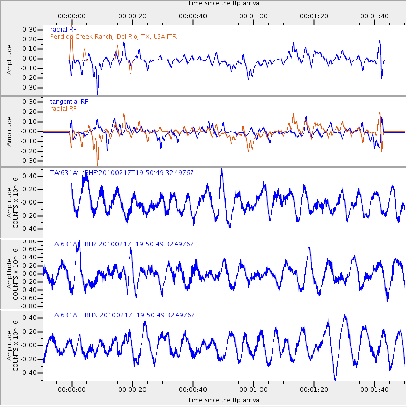
631A Perdido Creek Ranch, Del Rio, TX, USA - Earthquake Result Viewer
*The percent match for this event was below the threshold and hence no stack was calculated.
| Earthquake location: |
Kermadec Islands, New Zealand |
| Earthquake latitude/longitude: |
-29.8/-177.8 |
| Earthquake time(UTC): |
2010/02/17 (048) 19:38:06 GMT |
| Earthquake Depth: |
45 km |
| Earthquake Magnitude: |
5.8 MB, 5.5 MS, 5.9 MW, 5.9 MW |
| Earthquake Catalog/Contributor: |
WHDF/NEIC |
|
| Network: |
TA USArray Transportable Network (new EarthScope stations) |
| Station: |
631A Perdido Creek Ranch, Del Rio, TX, USA |
| Lat/Lon: |
29.41 N/100.58 W |
| Elevation: |
344 m |
|
| Distance: |
94.2 deg |
| Az: |
58.58 deg |
| Baz: |
238.266 deg |
| Ray Param: |
$rayparam |
*The percent match for this event was below the threshold and hence was not used in the summary stack. |
|
| Radial Match: |
51.73618 % |
| Radial Bump: |
400 |
| Transverse Match: |
40.628193 % |
| Transverse Bump: |
400 |
| SOD ConfigId: |
306082 |
| Insert Time: |
2010-05-06 07:49:16.645 +0000 |
| GWidth: |
2.5 |
| Max Bumps: |
400 |
| Tol: |
0.001 |
|
Signal To Noise
| Channel | StoN | STA | LTA |
| TA:631A: :BHZ:20100217T19:50:49.324976Z | 2.9094002 | 4.1318577E-7 | 1.4201751E-7 |
| TA:631A: :BHN:20100217T19:50:49.324976Z | 1.1642964 | 1.0357517E-7 | 8.8959446E-8 |
| TA:631A: :BHE:20100217T19:50:49.324976Z | 0.61719555 | 9.9583794E-8 | 1.6134885E-7 |
| Arrivals |
| Ps | |
| PpPs | |
| PsPs/PpSs | |


