You are here: Home > Network List > UW - Pacific Northwest Regional Seismic Network Stations List
> Station PASS Maple Falls, WA, USA > Earthquake Result Viewer
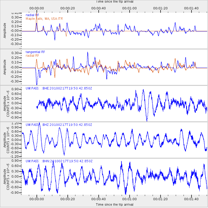
PASS Maple Falls, WA, USA - Earthquake Result Viewer
*The percent match for this event was below the threshold and hence no stack was calculated.
| Earthquake location: |
Kermadec Islands, New Zealand |
| Earthquake latitude/longitude: |
-29.8/-177.8 |
| Earthquake time(UTC): |
2010/02/17 (048) 19:38:06 GMT |
| Earthquake Depth: |
45 km |
| Earthquake Magnitude: |
5.8 MB, 5.5 MS, 5.9 MW, 5.9 MW |
| Earthquake Catalog/Contributor: |
WHDF/NEIC |
|
| Network: |
UW Pacific Northwest Regional Seismic Network |
| Station: |
PASS Maple Falls, WA, USA |
| Lat/Lon: |
49.00 N/122.09 W |
| Elevation: |
174 m |
|
| Distance: |
92.8 deg |
| Az: |
33.028 deg |
| Baz: |
226.027 deg |
| Ray Param: |
$rayparam |
*The percent match for this event was below the threshold and hence was not used in the summary stack. |
|
| Radial Match: |
55.214516 % |
| Radial Bump: |
400 |
| Transverse Match: |
51.85229 % |
| Transverse Bump: |
400 |
| SOD ConfigId: |
306082 |
| Insert Time: |
2010-05-06 07:51:49.989 +0000 |
| GWidth: |
2.5 |
| Max Bumps: |
400 |
| Tol: |
0.001 |
|
Signal To Noise
| Channel | StoN | STA | LTA |
| UW:PASS: :BHZ:20100217T19:50:42.850Z | 2.131087 | 7.338852E-7 | 3.443713E-7 |
| UW:PASS: :BHN:20100217T19:50:42.850Z | 1.9915661 | 4.4478125E-7 | 2.233324E-7 |
| UW:PASS: :BHE:20100217T19:50:42.850Z | 1.1637745 | 2.2940509E-7 | 1.9712161E-7 |
| Arrivals |
| Ps | |
| PpPs | |
| PsPs/PpSs | |


