You are here: Home > Network List > IU - Global Seismograph Network (GSN - IRIS/USGS) Stations List
> Station RSSD Black Hills, South Dakota, USA > Earthquake Result Viewer
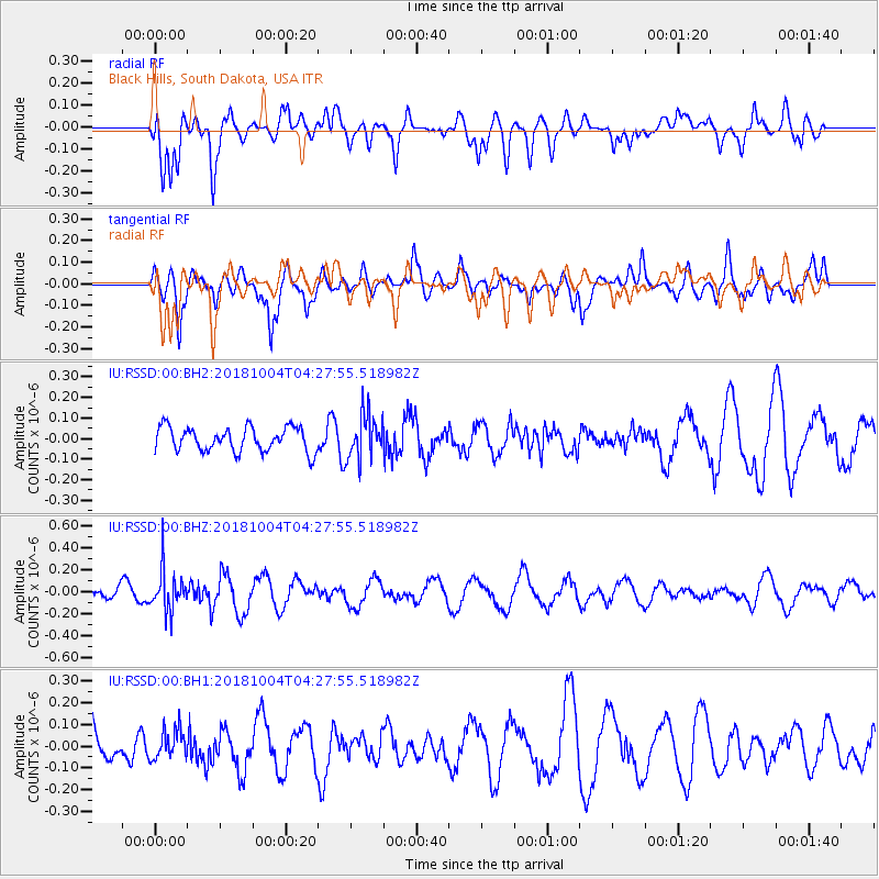
RSSD Black Hills, South Dakota, USA - Earthquake Result Viewer
*The percent match for this event was below the threshold and hence no stack was calculated.
| Earthquake location: |
Fiji Islands Region |
| Earthquake latitude/longitude: |
-17.9/-178.5 |
| Earthquake time(UTC): |
2018/10/04 (277) 04:16:21 GMT |
| Earthquake Depth: |
579 km |
| Earthquake Magnitude: |
5.5 Mww |
| Earthquake Catalog/Contributor: |
NEIC PDE/us |
|
| Network: |
IU Global Seismograph Network (GSN - IRIS/USGS) |
| Station: |
RSSD Black Hills, South Dakota, USA |
| Lat/Lon: |
44.12 N/104.04 W |
| Elevation: |
2090 m |
|
| Distance: |
91.6 deg |
| Az: |
43.971 deg |
| Baz: |
246.653 deg |
| Ray Param: |
$rayparam |
*The percent match for this event was below the threshold and hence was not used in the summary stack. |
|
| Radial Match: |
72.75978 % |
| Radial Bump: |
400 |
| Transverse Match: |
70.34807 % |
| Transverse Bump: |
400 |
| SOD ConfigId: |
3045211 |
| Insert Time: |
2018-10-18 04:29:11.673 +0000 |
| GWidth: |
2.5 |
| Max Bumps: |
400 |
| Tol: |
0.001 |
|
Signal To Noise
| Channel | StoN | STA | LTA |
| IU:RSSD:00:BHZ:20181004T04:27:55.518982Z | 1.9842637 | 1.8584865E-7 | 9.3661264E-8 |
| IU:RSSD:00:BH1:20181004T04:27:55.518982Z | 0.8822412 | 6.5960265E-8 | 7.4764436E-8 |
| IU:RSSD:00:BH2:20181004T04:27:55.518982Z | 1.8192574 | 1.0653028E-7 | 5.8557017E-8 |
| Arrivals |
| Ps | |
| PpPs | |
| PsPs/PpSs | |


