You are here: Home > Network List > GB - Great Britain Seismograph Network Stations List
> Station MCH1 MICHAELCHURCH, WALES > Earthquake Result Viewer
MCH1 MICHAELCHURCH, WALES - Earthquake Result Viewer
| Earthquake location: |
Hindu Kush Region, Afghanistan |
| Earthquake latitude/longitude: |
36.5/71.0 |
| Earthquake time(UTC): |
2023/03/21 (080) 16:47:23 GMT |
| Earthquake Depth: |
188 km |
| Earthquake Magnitude: |
6.5 Mww |
| Earthquake Catalog/Contributor: |
NEIC PDE/us |
|
| Network: |
GB Great Britain Seismograph Network |
| Station: |
MCH1 MICHAELCHURCH, WALES |
| Lat/Lon: |
52.00 N/3.00 W |
| Elevation: |
219 m |
|
| Distance: |
52.9 deg |
| Az: |
311.836 deg |
| Baz: |
76.1 deg |
| Ray Param: |
0.06579275 |
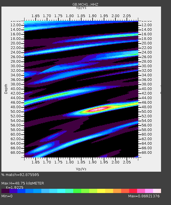
| Estimated Moho Depth: |
48.75 km |
| Estimated Crust Vp/Vs: |
1.92 |
| Assumed Crust Vp: |
6.182 km/s |
| Estimated Crust Vs: |
3.216 km/s |
| Estimated Crust Poisson's Ratio: |
0.31 |
|
| Radial Match: |
92.875595 % |
| Radial Bump: |
326 |
| Transverse Match: |
92.3744 % |
| Transverse Bump: |
398 |
| SOD ConfigId: |
30536071 |
| Insert Time: |
2023-04-04 17:04:00.886 +0000 |
| GWidth: |
2.5 |
| Max Bumps: |
400 |
| Tol: |
0.001 |
|

Signal To Noise
| Channel | StoN | STA | LTA |
| GB:MCH1: :HHZ:20230321T16:55:49.700005Z | 12.782194 | 2.3133468E-6 | 1.8098198E-7 |
| GB:MCH1: :HHN:20230321T16:55:49.700005Z | 2.97788 | 3.4317569E-7 | 1.1524161E-7 |
| GB:MCH1: :HHE:20230321T16:55:49.700005Z | 6.345167 | 1.0954794E-6 | 1.7264784E-7 |
| Arrivals |
| Ps | 7.6 SECOND |
| PpPs | 22 SECOND |
| PsPs/PpSs | 30 SECOND |


