You are here: Home > Network List > IU - Global Seismograph Network (GSN - IRIS/USGS) Stations List
> Station GRFO Grafenberg, Germany > Earthquake Result Viewer
GRFO Grafenberg, Germany - Earthquake Result Viewer
| Earthquake location: |
Hindu Kush Region, Afghanistan |
| Earthquake latitude/longitude: |
36.5/71.0 |
| Earthquake time(UTC): |
2023/03/21 (080) 16:47:23 GMT |
| Earthquake Depth: |
188 km |
| Earthquake Magnitude: |
6.5 Mww |
| Earthquake Catalog/Contributor: |
NEIC PDE/us |
|
| Network: |
IU Global Seismograph Network (GSN - IRIS/USGS) |
| Station: |
GRFO Grafenberg, Germany |
| Lat/Lon: |
49.69 N/11.22 E |
| Elevation: |
384 m |
|
| Distance: |
44.4 deg |
| Az: |
306.734 deg |
| Baz: |
83.741 deg |
| Ray Param: |
0.0712051 |
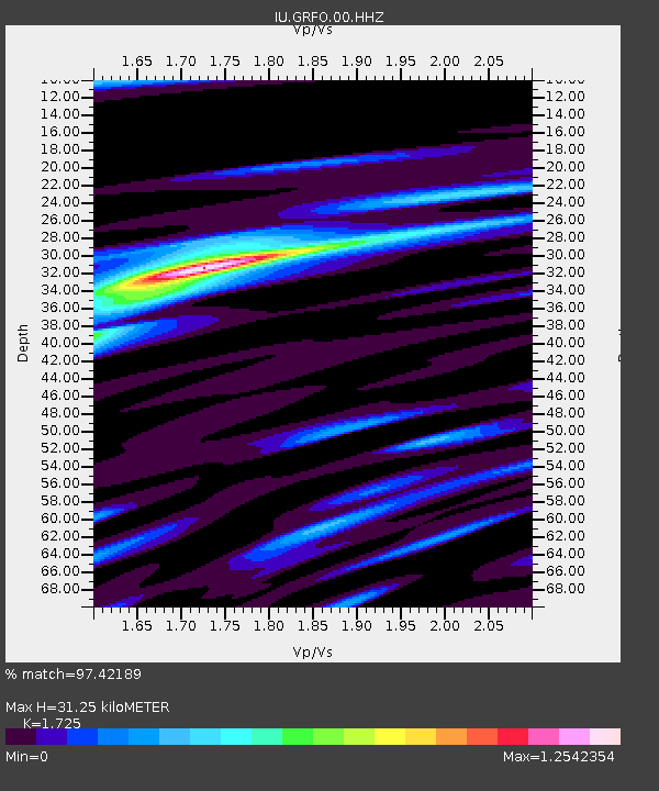
| Estimated Moho Depth: |
31.25 km |
| Estimated Crust Vp/Vs: |
1.73 |
| Assumed Crust Vp: |
6.182 km/s |
| Estimated Crust Vs: |
3.584 km/s |
| Estimated Crust Poisson's Ratio: |
0.25 |
|
| Radial Match: |
97.42189 % |
| Radial Bump: |
250 |
| Transverse Match: |
89.81362 % |
| Transverse Bump: |
390 |
| SOD ConfigId: |
30536071 |
| Insert Time: |
2023-04-04 17:05:27.187 +0000 |
| GWidth: |
2.5 |
| Max Bumps: |
400 |
| Tol: |
0.001 |
|

Signal To Noise
| Channel | StoN | STA | LTA |
| IU:GRFO:00:HHZ:20230321T16:54:45.338005Z | 76.008865 | 1.7220686E-5 | 2.2656155E-7 |
| IU:GRFO:00:HH1:20230321T16:54:45.338005Z | 10.893578 | 3.60453E-6 | 3.3088577E-7 |
| IU:GRFO:00:HH2:20230321T16:54:45.338005Z | 27.81193 | 9.43177E-6 | 3.391268E-7 |
| Arrivals |
| Ps | 3.9 SECOND |
| PpPs | 13 SECOND |
| PsPs/PpSs | 17 SECOND |


