You are here: Home > Network List > IU - Global Seismograph Network (GSN - IRIS/USGS) Stations List
> Station PMG Port Moresby, New Guinea > Earthquake Result Viewer
PMG Port Moresby, New Guinea - Earthquake Result Viewer

| Earthquake location: |
Hindu Kush Region, Afghanistan |
| Earthquake latitude/longitude: |
36.5/71.0 |
| Earthquake time(UTC): |
2023/03/21 (080) 16:47:23 GMT |
| Earthquake Depth: |
188 km |
| Earthquake Magnitude: |
6.5 Mww |
| Earthquake Catalog/Contributor: |
NEIC PDE/us |
|
| Network: |
IU Global Seismograph Network (GSN - IRIS/USGS) |
| Station: |
PMG Port Moresby, New Guinea |
| Lat/Lon: |
9.40 S/147.16 E |
| Elevation: |
90 m |
|
| Distance: |
84.6 deg |
| Az: |
105.761 deg |
| Baz: |
308.218 deg |
| Ray Param: |
0.044903204 |
| Estimated Moho Depth: |
43.5 km |
| Estimated Crust Vp/Vs: |
1.65 |
| Assumed Crust Vp: |
6.122 km/s |
| Estimated Crust Vs: |
3.71 km/s |
| Estimated Crust Poisson's Ratio: |
0.21 |
|
| Radial Match: |
96.99421 % |
| Radial Bump: |
400 |
| Transverse Match: |
97.70862 % |
| Transverse Bump: |
309 |
| SOD ConfigId: |
30536071 |
| Insert Time: |
2023-04-04 17:05:42.215 +0000 |
| GWidth: |
2.5 |
| Max Bumps: |
400 |
| Tol: |
0.001 |
|
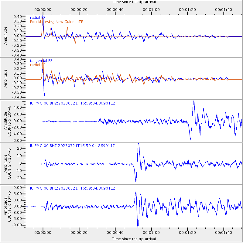
Signal To Noise
| Channel | StoN | STA | LTA |
| IU:PMG:00:BHZ:20230321T16:59:04.869011Z | 22.537193 | 2.1850722E-6 | 9.6954054E-8 |
| IU:PMG:00:BH1:20230321T16:59:04.869011Z | 11.788134 | 1.127483E-6 | 9.564558E-8 |
| IU:PMG:00:BH2:20230321T16:59:04.869011Z | 4.149491 | 3.532859E-7 | 8.513958E-8 |
| Arrivals |
| Ps | 4.7 SECOND |
| PpPs | 18 SECOND |
| PsPs/PpSs | 23 SECOND |


