You are here: Home > Network List > US - United States National Seismic Network Stations List
> Station HAWA Hanford, Washington, USA > Earthquake Result Viewer
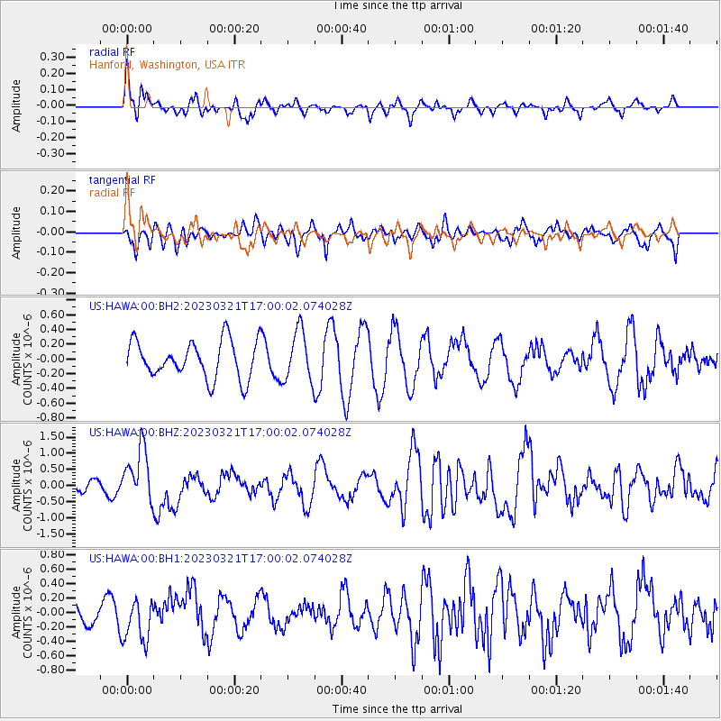
HAWA Hanford, Washington, USA - Earthquake Result Viewer
*The percent match for this event was below the threshold and hence no stack was calculated.
| Earthquake location: |
Hindu Kush Region, Afghanistan |
| Earthquake latitude/longitude: |
36.5/71.0 |
| Earthquake time(UTC): |
2023/03/21 (080) 16:47:23 GMT |
| Earthquake Depth: |
188 km |
| Earthquake Magnitude: |
6.5 Mww |
| Earthquake Catalog/Contributor: |
NEIC PDE/us |
|
| Network: |
US United States National Seismic Network |
| Station: |
HAWA Hanford, Washington, USA |
| Lat/Lon: |
46.39 N/119.53 W |
| Elevation: |
364 m |
|
| Distance: |
96.9 deg |
| Az: |
7.307 deg |
| Baz: |
351.487 deg |
| Ray Param: |
$rayparam |
*The percent match for this event was below the threshold and hence was not used in the summary stack. |
|
| Radial Match: |
56.9142 % |
| Radial Bump: |
400 |
| Transverse Match: |
37.32261 % |
| Transverse Bump: |
400 |
| SOD ConfigId: |
30536071 |
| Insert Time: |
2023-04-04 17:12:04.118 +0000 |
| GWidth: |
2.5 |
| Max Bumps: |
400 |
| Tol: |
0.001 |
|
Signal To Noise
| Channel | StoN | STA | LTA |
| US:HAWA:00:BHZ:20230321T17:00:02.074028Z | 3.0924828 | 8.496944E-7 | 2.7476125E-7 |
| US:HAWA:00:BH1:20230321T17:00:02.074028Z | 1.7135751 | 2.970756E-7 | 1.7336595E-7 |
| US:HAWA:00:BH2:20230321T17:00:02.074028Z | 1.3744806 | 3.4469073E-7 | 2.507789E-7 |
| Arrivals |
| Ps | |
| PpPs | |
| PsPs/PpSs | |


