You are here: Home > Network List > US - United States National Seismic Network Stations List
> Station BOZ Bozeman, Montana, USA > Earthquake Result Viewer
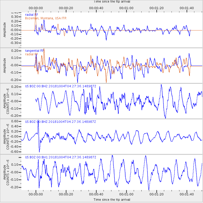
BOZ Bozeman, Montana, USA - Earthquake Result Viewer
*The percent match for this event was below the threshold and hence no stack was calculated.
| Earthquake location: |
Fiji Islands Region |
| Earthquake latitude/longitude: |
-17.9/-178.5 |
| Earthquake time(UTC): |
2018/10/04 (277) 04:16:21 GMT |
| Earthquake Depth: |
579 km |
| Earthquake Magnitude: |
5.5 Mww |
| Earthquake Catalog/Contributor: |
NEIC PDE/us |
|
| Network: |
US United States National Seismic Network |
| Station: |
BOZ Bozeman, Montana, USA |
| Lat/Lon: |
45.65 N/111.63 W |
| Elevation: |
1589 m |
|
| Distance: |
87.4 deg |
| Az: |
40.235 deg |
| Baz: |
241.277 deg |
| Ray Param: |
$rayparam |
*The percent match for this event was below the threshold and hence was not used in the summary stack. |
|
| Radial Match: |
74.26214 % |
| Radial Bump: |
400 |
| Transverse Match: |
56.99804 % |
| Transverse Bump: |
400 |
| SOD ConfigId: |
3045211 |
| Insert Time: |
2018-10-18 04:31:34.326 +0000 |
| GWidth: |
2.5 |
| Max Bumps: |
400 |
| Tol: |
0.001 |
|
Signal To Noise
| Channel | StoN | STA | LTA |
| US:BOZ:00:BHZ:20181004T04:27:36.148987Z | 3.0803409 | 2.7621044E-7 | 8.966879E-8 |
| US:BOZ:00:BH1:20181004T04:27:36.148987Z | 0.80217093 | 9.004002E-8 | 1.1224543E-7 |
| US:BOZ:00:BH2:20181004T04:27:36.148987Z | 1.1582029 | 1.0147436E-7 | 8.7613635E-8 |
| Arrivals |
| Ps | |
| PpPs | |
| PsPs/PpSs | |


