You are here: Home > Network List > UW - Pacific Northwest Regional Seismic Network Stations List
> Station HOOD Mt Hood Meadows, OR CREST BB SMO > Earthquake Result Viewer
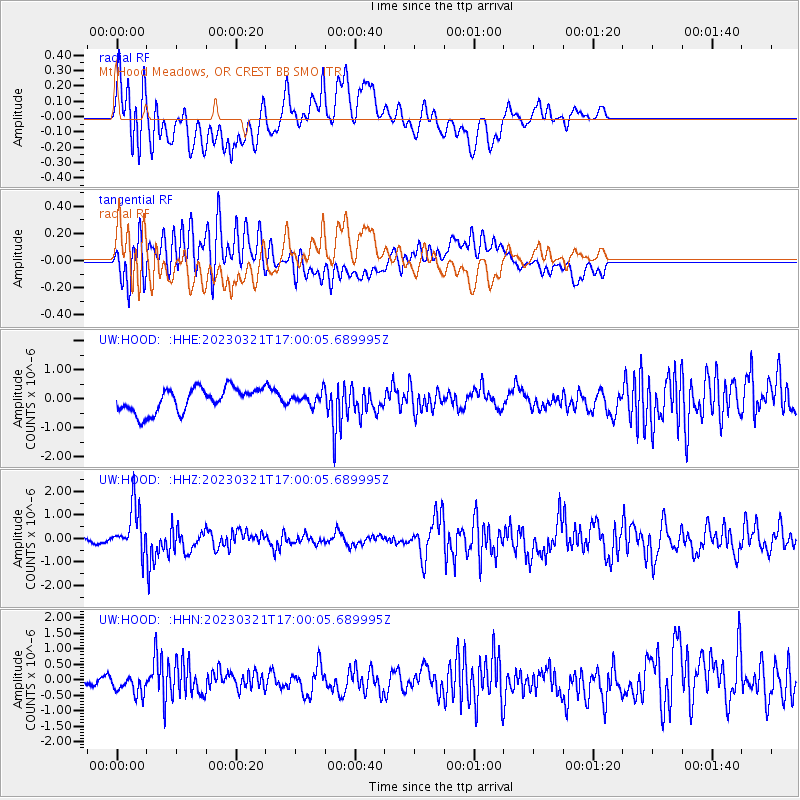
HOOD Mt Hood Meadows, OR CREST BB SMO - Earthquake Result Viewer
*The percent match for this event was below the threshold and hence no stack was calculated.
| Earthquake location: |
Hindu Kush Region, Afghanistan |
| Earthquake latitude/longitude: |
36.5/71.0 |
| Earthquake time(UTC): |
2023/03/21 (080) 16:47:23 GMT |
| Earthquake Depth: |
188 km |
| Earthquake Magnitude: |
6.5 Mww |
| Earthquake Catalog/Contributor: |
NEIC PDE/us |
|
| Network: |
UW Pacific Northwest Regional Seismic Network |
| Station: |
HOOD Mt Hood Meadows, OR CREST BB SMO |
| Lat/Lon: |
45.32 N/121.65 W |
| Elevation: |
1520 m |
|
| Distance: |
97.7 deg |
| Az: |
8.958 deg |
| Baz: |
349.76 deg |
| Ray Param: |
$rayparam |
*The percent match for this event was below the threshold and hence was not used in the summary stack. |
|
| Radial Match: |
68.53719 % |
| Radial Bump: |
400 |
| Transverse Match: |
61.076515 % |
| Transverse Bump: |
400 |
| SOD ConfigId: |
30536071 |
| Insert Time: |
2023-04-04 17:13:42.824 +0000 |
| GWidth: |
2.5 |
| Max Bumps: |
400 |
| Tol: |
0.001 |
|
Signal To Noise
| Channel | StoN | STA | LTA |
| UW:HOOD: :HHZ:20230321T17:00:05.689995Z | 9.684034 | 1.0202472E-6 | 1.0535352E-7 |
| UW:HOOD: :HHN:20230321T17:00:05.689995Z | 1.3422102 | 3.5098859E-7 | 2.6150047E-7 |
| UW:HOOD: :HHE:20230321T17:00:05.689995Z | 0.49173442 | 2.0264527E-7 | 4.1210305E-7 |
| Arrivals |
| Ps | |
| PpPs | |
| PsPs/PpSs | |


