You are here: Home > Network List > G - GEOSCOPE Stations List
> Station PPTF Pamatai - Papeete - Tahiti island - French Polynesia, France > Earthquake Result Viewer
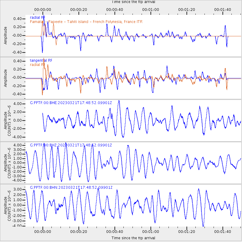
PPTF Pamatai - Papeete - Tahiti island - French Polynesia, France - Earthquake Result Viewer
*The percent match for this event was below the threshold and hence no stack was calculated.
| Earthquake location: |
Near Coast Of Central Chile |
| Earthquake latitude/longitude: |
-33.6/-71.4 |
| Earthquake time(UTC): |
2023/03/21 (080) 17:38:13 GMT |
| Earthquake Depth: |
65 km |
| Earthquake Magnitude: |
5.6 Mww |
| Earthquake Catalog/Contributor: |
NEIC PDE/us |
|
| Network: |
G GEOSCOPE |
| Station: |
PPTF Pamatai - Papeete - Tahiti island - French Polynesia, France |
| Lat/Lon: |
17.59 S/149.57 W |
| Elevation: |
705 m |
|
| Distance: |
70.8 deg |
| Az: |
261.274 deg |
| Baz: |
120.14 deg |
| Ray Param: |
$rayparam |
*The percent match for this event was below the threshold and hence was not used in the summary stack. |
|
| Radial Match: |
53.476807 % |
| Radial Bump: |
400 |
| Transverse Match: |
50.248047 % |
| Transverse Bump: |
400 |
| SOD ConfigId: |
30536071 |
| Insert Time: |
2023-04-04 17:44:24.314 +0000 |
| GWidth: |
2.5 |
| Max Bumps: |
400 |
| Tol: |
0.001 |
|
Signal To Noise
| Channel | StoN | STA | LTA |
| G:PPTF:00:BHZ:20230321T17:48:52.09901Z | 1.5940626 | 2.8003242E-6 | 1.7567216E-6 |
| G:PPTF:00:BHN:20230321T17:48:52.09901Z | 1.2223485 | 1.7008243E-6 | 1.3914398E-6 |
| G:PPTF:00:BHE:20230321T17:48:52.09901Z | 1.1133814 | 1.1381749E-6 | 1.0222686E-6 |
| Arrivals |
| Ps | |
| PpPs | |
| PsPs/PpSs | |


