You are here: Home > Network List > CI - Caltech Regional Seismic Network Stations List
> Station TUQ Turquiose Mountain, Baker, CA, USA > Earthquake Result Viewer
TUQ Turquiose Mountain, Baker, CA, USA - Earthquake Result Viewer
| Earthquake location: |
E. Russia-N.E. China Border Reg. |
| Earthquake latitude/longitude: |
42.6/130.7 |
| Earthquake time(UTC): |
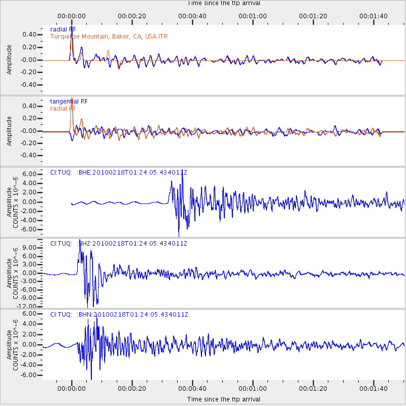
2010/02/18 (049) 01:13:19 GMT |
| Earthquake Depth: |
578 km |
| Earthquake Magnitude: |
6.3 MB, 6.9 MW, 6.9 MW |
| Earthquake Catalog/Contributor: |
WHDF/NEIC |
|
| Network: |
CI Caltech Regional Seismic Network |
| Station: |
TUQ Turquiose Mountain, Baker, CA, USA |
| Lat/Lon: |
35.44 N/115.92 W |
| Elevation: |
1350 m |
|
| Distance: |
81.4 deg |
| Az: |
49.302 deg |
| Baz: |
316.713 deg |
| Ray Param: |
0.04588164 |
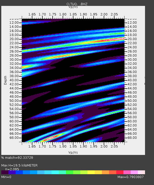
| Estimated Moho Depth: |
19.5 km |
| Estimated Crust Vp/Vs: |
2.10 |
| Assumed Crust Vp: |
6.276 km/s |
| Estimated Crust Vs: |
2.996 km/s |
| Estimated Crust Poisson's Ratio: |
0.35 |
|
| Radial Match: |
92.33729 % |
| Radial Bump: |
400 |
| Transverse Match: |
88.38188 % |
| Transverse Bump: |
400 |
| SOD ConfigId: |
306082 |
| Insert Time: |
2010-05-06 08:03:00.604 +0000 |
| GWidth: |
2.5 |
| Max Bumps: |
400 |
| Tol: |
0.001 |
|
Signal To Noise
| Channel | StoN | STA | LTA |
| CI:TUQ: :BHZ:20100218T01:24:05.434011Z | 20.709328 | 4.8133084E-6 | 2.3242222E-7 |
| CI:TUQ: :BHN:20100218T01:24:05.434011Z | 6.142276 | 1.4007583E-6 | 2.28052E-7 |
| CI:TUQ: :BHE:20100218T01:24:05.434011Z | 9.210112 | 1.7580148E-6 | 1.908788E-7 |
| Arrivals |
| Ps | 3.5 SECOND |
| PpPs | 9.4 SECOND |
| PsPs/PpSs | 13 SECOND |


