You are here: Home > Network List > II - Global Seismograph Network (GSN - IRIS/IDA) Stations List
> Station PFO Pinon Flat, California, USA > Earthquake Result Viewer
PFO Pinon Flat, California, USA - Earthquake Result Viewer
| Earthquake location: |
E. Russia-N.E. China Border Reg. |
| Earthquake latitude/longitude: |
42.6/130.7 |
| Earthquake time(UTC): |
2010/02/18 (049) 01:13:19 GMT |
| Earthquake Depth: |
578 km |
| Earthquake Magnitude: |
6.3 MB, 6.9 MW, 6.9 MW |
| Earthquake Catalog/Contributor: |
WHDF/NEIC |
|
| Network: |
II Global Seismograph Network (GSN - IRIS/IDA) |
| Station: |
PFO Pinon Flat, California, USA |
| Lat/Lon: |
33.61 N/116.46 W |
| Elevation: |
1280 m |
|
| Distance: |
82.4 deg |
| Az: |
50.887 deg |
| Baz: |
316.636 deg |
| Ray Param: |
0.045189977 |
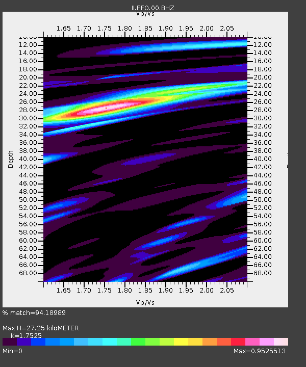
| Estimated Moho Depth: |
27.25 km |
| Estimated Crust Vp/Vs: |
1.75 |
| Assumed Crust Vp: |
6.264 km/s |
| Estimated Crust Vs: |
3.574 km/s |
| Estimated Crust Poisson's Ratio: |
0.26 |
|
| Radial Match: |
94.18989 % |
| Radial Bump: |
400 |
| Transverse Match: |
82.83591 % |
| Transverse Bump: |
400 |
| SOD ConfigId: |
306082 |
| Insert Time: |
2010-05-06 08:05:46.408 +0000 |
| GWidth: |
2.5 |
| Max Bumps: |
400 |
| Tol: |
0.001 |
|

Signal To Noise
| Channel | StoN | STA | LTA |
| II:PFO:00:BHZ:20100218T01:24:10.619985Z | 24.057014 | 4.4956287E-6 | 1.8687393E-7 |
| II:PFO:00:BHN:20100218T01:24:10.619985Z | 5.937812 | 1.3109186E-6 | 2.2077468E-7 |
| II:PFO:00:BHE:20100218T01:24:10.619985Z | 6.1396446 | 9.814701E-7 | 1.598578E-7 |
| Arrivals |
| Ps | 3.4 SECOND |
| PpPs | 12 SECOND |
| PsPs/PpSs | 15 SECOND |


