You are here: Home > Network List > US - United States National Seismic Network Stations List
> Station HAWA Hanford, Washington, USA > Earthquake Result Viewer
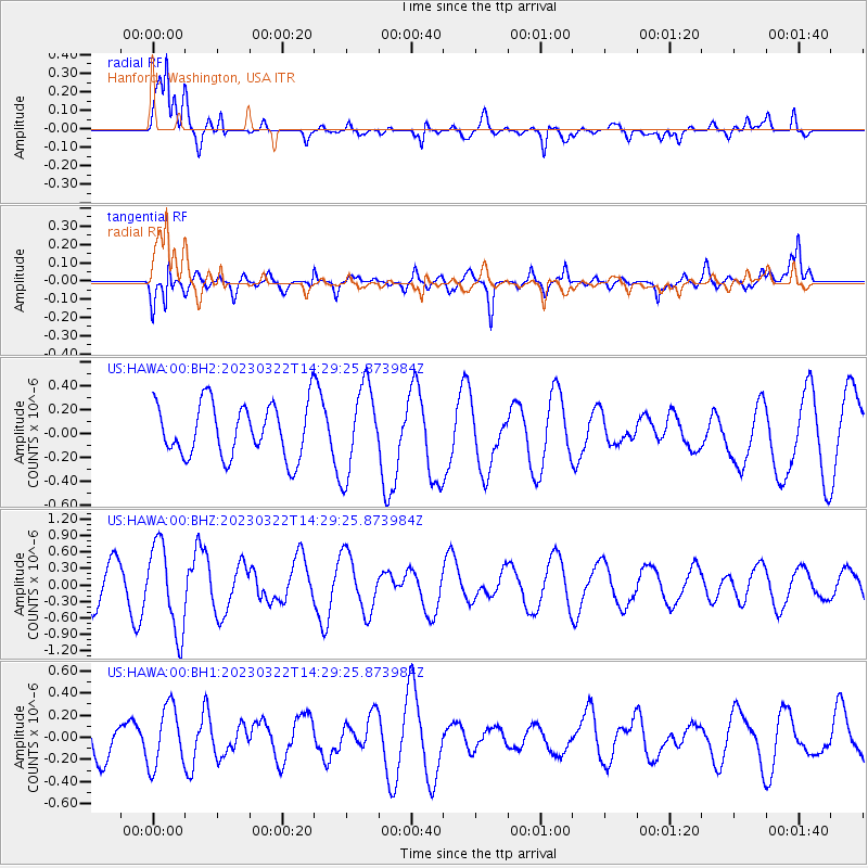
HAWA Hanford, Washington, USA - Earthquake Result Viewer
*The percent match for this event was below the threshold and hence no stack was calculated.
| Earthquake location: |
Kermadec Islands, New Zealand |
| Earthquake latitude/longitude: |
-30.3/-177.3 |
| Earthquake time(UTC): |
2023/03/22 (081) 14:16:46 GMT |
| Earthquake Depth: |
10 km |
| Earthquake Magnitude: |
5.5 mb |
| Earthquake Catalog/Contributor: |
NEIC PDE/us |
|
| Network: |
US United States National Seismic Network |
| Station: |
HAWA Hanford, Washington, USA |
| Lat/Lon: |
46.39 N/119.53 W |
| Elevation: |
364 m |
|
| Distance: |
92.4 deg |
| Az: |
35.882 deg |
| Baz: |
227.108 deg |
| Ray Param: |
$rayparam |
*The percent match for this event was below the threshold and hence was not used in the summary stack. |
|
| Radial Match: |
67.32222 % |
| Radial Bump: |
400 |
| Transverse Match: |
54.86394 % |
| Transverse Bump: |
400 |
| SOD ConfigId: |
30536071 |
| Insert Time: |
2023-04-05 14:31:42.905 +0000 |
| GWidth: |
2.5 |
| Max Bumps: |
400 |
| Tol: |
0.001 |
|
Signal To Noise
| Channel | StoN | STA | LTA |
| US:HAWA:00:BHZ:20230322T14:29:25.873984Z | 2.3603652 | 7.93432E-7 | 3.3614796E-7 |
| US:HAWA:00:BH1:20230322T14:29:25.873984Z | 1.499689 | 2.7486E-7 | 1.8327802E-7 |
| US:HAWA:00:BH2:20230322T14:29:25.873984Z | 1.6402358 | 3.680723E-7 | 2.2440207E-7 |
| Arrivals |
| Ps | |
| PpPs | |
| PsPs/PpSs | |


