You are here: Home > Network List > GS - US Geological Survey Networks Stations List
> Station OK051 E0350 and S34600 Roads, Ralston, OK > Earthquake Result Viewer
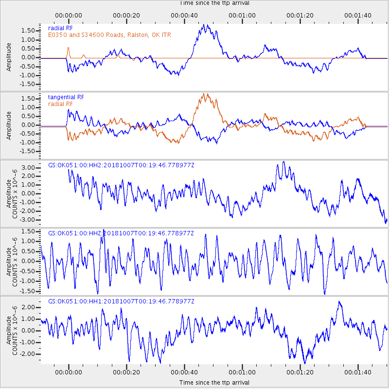
OK051 E0350 and S34600 Roads, Ralston, OK - Earthquake Result Viewer
*The percent match for this event was below the threshold and hence no stack was calculated.
| Earthquake location: |
Central Mid-Atlantic Ridge |
| Earthquake latitude/longitude: |
7.6/-37.7 |
| Earthquake time(UTC): |
2018/10/07 (280) 00:10:05 GMT |
| Earthquake Depth: |
10 km |
| Earthquake Magnitude: |
5.6 Mww |
| Earthquake Catalog/Contributor: |
NEIC PDE/us |
|
| Network: |
GS US Geological Survey Networks |
| Station: |
OK051 E0350 and S34600 Roads, Ralston, OK |
| Lat/Lon: |
36.51 N/96.84 W |
| Elevation: |
263 m |
|
| Distance: |
60.9 deg |
| Az: |
307.611 deg |
| Baz: |
102.915 deg |
| Ray Param: |
$rayparam |
*The percent match for this event was below the threshold and hence was not used in the summary stack. |
|
| Radial Match: |
50.909424 % |
| Radial Bump: |
400 |
| Transverse Match: |
47.756298 % |
| Transverse Bump: |
400 |
| SOD ConfigId: |
3045211 |
| Insert Time: |
2018-10-21 00:23:12.926 +0000 |
| GWidth: |
2.5 |
| Max Bumps: |
400 |
| Tol: |
0.001 |
|
Signal To Noise
| Channel | StoN | STA | LTA |
| GS:OK051:00:HHZ:20181007T00:19:46.778977Z | 0.8171671 | 6.04904E-7 | 7.4024524E-7 |
| GS:OK051:00:HH1:20181007T00:19:46.778977Z | 0.97873944 | 1.0074124E-6 | 1.0292958E-6 |
| GS:OK051:00:HH2:20181007T00:19:46.778977Z | 1.5378591 | 1.4548781E-6 | 9.460412E-7 |
| Arrivals |
| Ps | |
| PpPs | |
| PsPs/PpSs | |


