You are here: Home > Network List > CI - Caltech Regional Seismic Network Stations List
> Station DAN Danby, California, USA > Earthquake Result Viewer
DAN Danby, California, USA - Earthquake Result Viewer
| Earthquake location: |
Jujuy Province, Argentina |
| Earthquake latitude/longitude: |
-23.5/-66.5 |
| Earthquake time(UTC): |
2023/03/22 (081) 16:00:31 GMT |
| Earthquake Depth: |
210 km |
| Earthquake Magnitude: |
6.5 mww |
| Earthquake Catalog/Contributor: |
NEIC PDE/us |
|
| Network: |
CI Caltech Regional Seismic Network |
| Station: |
DAN Danby, California, USA |
| Lat/Lon: |
34.64 N/115.38 W |
| Elevation: |
398 m |
|
| Distance: |
74.1 deg |
| Az: |
319.779 deg |
| Baz: |
134.022 deg |
| Ray Param: |
0.051989652 |
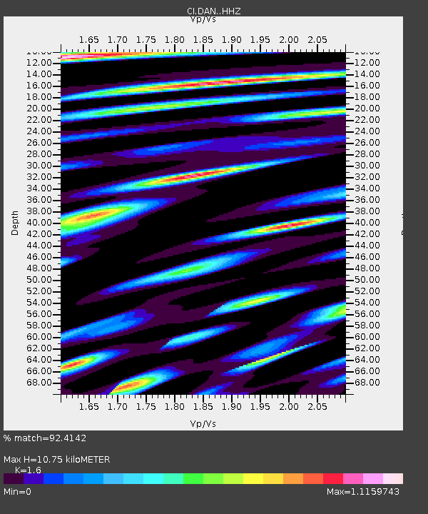
| Estimated Moho Depth: |
10.75 km |
| Estimated Crust Vp/Vs: |
1.60 |
| Assumed Crust Vp: |
6.276 km/s |
| Estimated Crust Vs: |
3.922 km/s |
| Estimated Crust Poisson's Ratio: |
0.18 |
|
| Radial Match: |
92.4142 % |
| Radial Bump: |
400 |
| Transverse Match: |
69.71685 % |
| Transverse Bump: |
400 |
| SOD ConfigId: |
30536071 |
| Insert Time: |
2023-04-05 16:07:13.686 +0000 |
| GWidth: |
2.5 |
| Max Bumps: |
400 |
| Tol: |
0.001 |
|
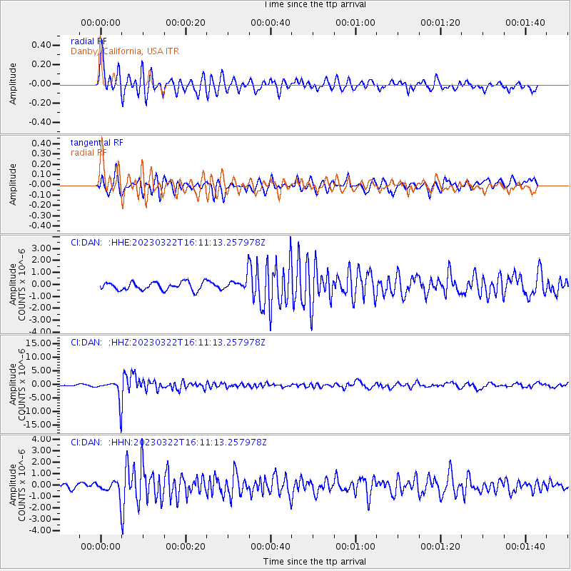
Signal To Noise
| Channel | StoN | STA | LTA |
| CI:DAN: :HHZ:20230322T16:11:13.257978Z | 12.607742 | 4.298595E-6 | 3.409488E-7 |
| CI:DAN: :HHN:20230322T16:11:13.257978Z | 3.181535 | 6.9009957E-7 | 2.1690774E-7 |
| CI:DAN: :HHE:20230322T16:11:13.257978Z | 1.9513211 | 6.409261E-7 | 3.2845753E-7 |
| Arrivals |
| Ps | 1.1 SECOND |
| PpPs | 4.3 SECOND |
| PsPs/PpSs | 5.4 SECOND |


