You are here: Home > Network List > MX - Mexican National Seismic Network Stations List
> Station MOIG Morelia, Mich, MX > Earthquake Result Viewer
MOIG Morelia, Mich, MX - Earthquake Result Viewer
| Earthquake location: |
Jujuy Province, Argentina |
| Earthquake latitude/longitude: |
-23.5/-66.5 |
| Earthquake time(UTC): |
2023/03/22 (081) 16:00:31 GMT |
| Earthquake Depth: |
210 km |
| Earthquake Magnitude: |
6.5 mww |
| Earthquake Catalog/Contributor: |
NEIC PDE/us |
|
| Network: |
MX Mexican National Seismic Network |
| Station: |
MOIG Morelia, Mich, MX |
| Lat/Lon: |
19.65 N/101.23 W |
| Elevation: |
2000 m |
|
| Distance: |
54.6 deg |
| Az: |
318.83 deg |
| Baz: |
140.111 deg |
| Ray Param: |
0.064604 |
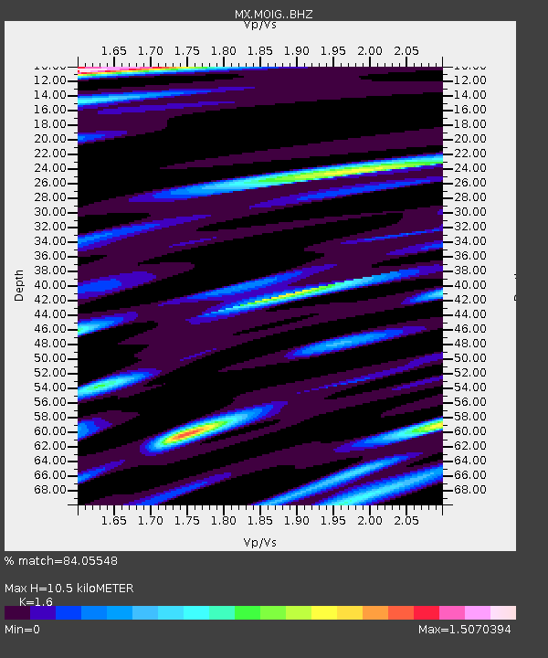
| Estimated Moho Depth: |
10.5 km |
| Estimated Crust Vp/Vs: |
1.60 |
| Assumed Crust Vp: |
6.566 km/s |
| Estimated Crust Vs: |
4.104 km/s |
| Estimated Crust Poisson's Ratio: |
0.18 |
|
| Radial Match: |
84.05548 % |
| Radial Bump: |
400 |
| Transverse Match: |
71.52615 % |
| Transverse Bump: |
400 |
| SOD ConfigId: |
30536071 |
| Insert Time: |
2023-04-05 16:16:13.179 +0000 |
| GWidth: |
2.5 |
| Max Bumps: |
400 |
| Tol: |
0.001 |
|

Signal To Noise
| Channel | StoN | STA | LTA |
| MX:MOIG: :BHZ:20230322T16:09:07.345014Z | 23.40963 | 5.639275E-6 | 2.4089553E-7 |
| MX:MOIG: :BHN:20230322T16:09:07.345014Z | 4.8206825 | 1.4935013E-6 | 3.0981116E-7 |
| MX:MOIG: :BHE:20230322T16:09:07.345014Z | 4.2730503 | 1.3112486E-6 | 3.068648E-7 |
| Arrivals |
| Ps | 1.0 SECOND |
| PpPs | 3.9 SECOND |
| PsPs/PpSs | 4.9 SECOND |


