You are here: Home > Network List > TA - USArray Transportable Network (new EarthScope stations) Stations List
> Station X18A Snowflake, AZ, USA > Earthquake Result Viewer
X18A Snowflake, AZ, USA - Earthquake Result Viewer
| Earthquake location: |
E. Russia-N.E. China Border Reg. |
| Earthquake latitude/longitude: |
42.6/130.7 |
| Earthquake time(UTC): |
2010/02/18 (049) 01:13:19 GMT |
| Earthquake Depth: |
578 km |
| Earthquake Magnitude: |
6.3 MB, 6.9 MW, 6.9 MW |
| Earthquake Catalog/Contributor: |
WHDF/NEIC |
|
| Network: |
TA USArray Transportable Network (new EarthScope stations) |
| Station: |
X18A Snowflake, AZ, USA |
| Lat/Lon: |
34.53 N/109.95 W |
| Elevation: |
1751 m |
|
| Distance: |
85.3 deg |
| Az: |
46.225 deg |
| Baz: |
319.767 deg |
| Ray Param: |
0.043184835 |
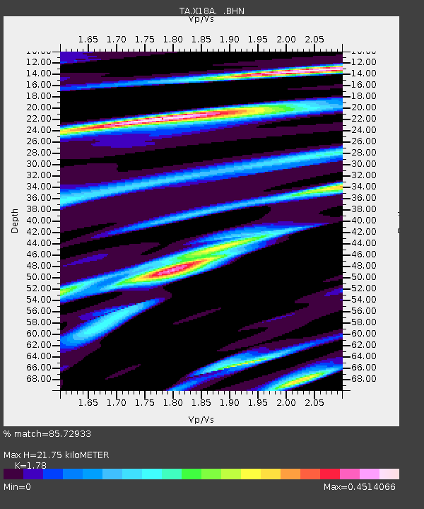
| Estimated Moho Depth: |
21.75 km |
| Estimated Crust Vp/Vs: |
1.78 |
| Assumed Crust Vp: |
6.496 km/s |
| Estimated Crust Vs: |
3.649 km/s |
| Estimated Crust Poisson's Ratio: |
0.27 |
|
| Radial Match: |
85.72933 % |
| Radial Bump: |
400 |
| Transverse Match: |
75.56792 % |
| Transverse Bump: |
400 |
| SOD ConfigId: |
306082 |
| Insert Time: |
2010-05-06 08:13:35.863 +0000 |
| GWidth: |
2.5 |
| Max Bumps: |
400 |
| Tol: |
0.001 |
|
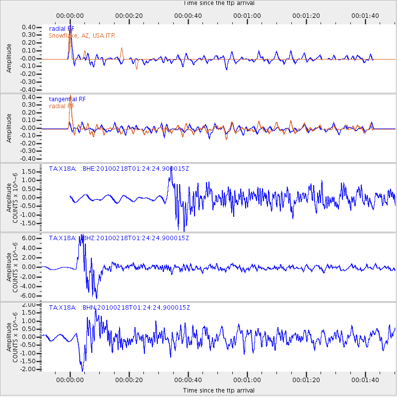
Signal To Noise
| Channel | StoN | STA | LTA |
| TA:X18A: :BHZ:20100218T01:24:24.900015Z | 13.589036 | 3.2099965E-6 | 2.3621959E-7 |
| TA:X18A: :BHN:20100218T01:24:24.900015Z | 4.5654306 | 9.140285E-7 | 2.0020642E-7 |
| TA:X18A: :BHE:20100218T01:24:24.900015Z | 5.226678 | 6.727991E-7 | 1.2872404E-7 |
| Arrivals |
| Ps | 2.7 SECOND |
| PpPs | 9.1 SECOND |
| PsPs/PpSs | 12 SECOND |


