You are here: Home > Network List > N4 - Central and EAstern US Network Stations List
> Station T47A Sharon Grove, KY, USA > Earthquake Result Viewer
T47A Sharon Grove, KY, USA - Earthquake Result Viewer
| Earthquake location: |
Jujuy Province, Argentina |
| Earthquake latitude/longitude: |
-23.5/-66.5 |
| Earthquake time(UTC): |
2023/03/22 (081) 16:00:31 GMT |
| Earthquake Depth: |
210 km |
| Earthquake Magnitude: |
6.5 mww |
| Earthquake Catalog/Contributor: |
NEIC PDE/us |
|
| Network: |
N4 Central and EAstern US Network |
| Station: |
T47A Sharon Grove, KY, USA |
| Lat/Lon: |
36.99 N/87.11 W |
| Elevation: |
217 m |
|
| Distance: |
63.2 deg |
| Az: |
341.607 deg |
| Baz: |
158.787 deg |
| Ray Param: |
0.05908353 |
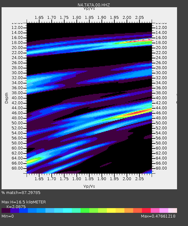
| Estimated Moho Depth: |
16.5 km |
| Estimated Crust Vp/Vs: |
2.09 |
| Assumed Crust Vp: |
6.444 km/s |
| Estimated Crust Vs: |
3.087 km/s |
| Estimated Crust Poisson's Ratio: |
0.35 |
|
| Radial Match: |
87.29785 % |
| Radial Bump: |
344 |
| Transverse Match: |
82.27485 % |
| Transverse Bump: |
385 |
| SOD ConfigId: |
30536071 |
| Insert Time: |
2023-04-05 16:18:56.880 +0000 |
| GWidth: |
2.5 |
| Max Bumps: |
400 |
| Tol: |
0.001 |
|

Signal To Noise
| Channel | StoN | STA | LTA |
| N4:T47A:00:HHZ:20230322T16:10:06.108991Z | 11.632428 | 4.4602275E-6 | 3.8343046E-7 |
| N4:T47A:00:HH1:20230322T16:10:06.108991Z | 6.4559927 | 1.0018717E-6 | 1.5518476E-7 |
| N4:T47A:00:HH2:20230322T16:10:06.108991Z | 6.022836 | 1.1996303E-6 | 1.9918029E-7 |
| Arrivals |
| Ps | 2.9 SECOND |
| PpPs | 7.6 SECOND |
| PsPs/PpSs | 11 SECOND |


